Detail View: Old Maps Collection: [River courses between Fou Tcheo and Nantchang Fou].
|
Barcode:
|
3687800354486J
|
|
Title:
|
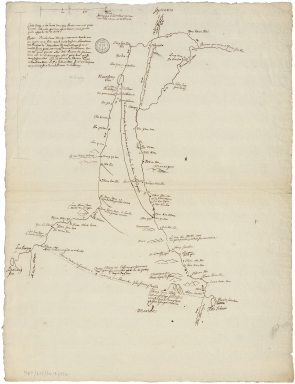
[River courses between Fou Tcheo and Nantchang Fou].
|
|
Category:
|
General Maps
|
|
Type:
|
Manuscript
|
|
Language:
|
French
|
|
Language:
|
Latin
|
|
Create Year:
|
[173-]
|
|
Scale:
|
Scale indeterminable.
|
|
Physical Map Dimension (cm):
|
60 x 46 cm, on sheet 66 x 52 cm
|
|
Note:
|
This is a map of the Minjiang River between the cities of Fucheu (Fou Tcheou) and Nanchang County (Nantchang Fou). Quite a number of annotations are given along the course of the river and its tributaries.
|
|
Note:
|
Original is a manuscript map.
|
|
Note:
|
Scale line in Chinese Li on the upper left corner of the map.
|
|
Note:
|
Relief shown pictorially.
|
|
Note:
|
The upper and bottom borders of the map labelled with North and South in Latin Septentrio (Septentriones) and Meridies respectively.
|
|
Note:
|
Notes in French with cardinal directions in Latin.
|
|
Subject:
|
Travel
|
|
Geographic Area:
|
China
|
|
Provenance:
|
Archives Nationales de France
|
|
Provenance Call No.:
|
MAP/6JJ/74/A/12b
|
|
MUST holding:
|
https://must.primo.exlibrisgroup.com/permalink/853MUST_INST/171sgkf/alma991003000649705076
|