Detail View: Old Maps Collection: Chine : suivant le P. Noël.
|
Barcode:
|
3687800354485I
|
|
Title:
|
Chine : suivant le P. Noël.
|
|
Category:
|
General Maps
|
|
Type:
|
Manuscript
|
|
Language:
|
French
|
|
Create Year:
|
[173-]
|
|
Scale:
|
Scale indeterminable.
|
|
Physical Map Dimension (cm):
|
31 x 40 cm, on sheet 40 x 46 cm
|
|
Note:
|
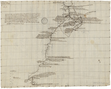
This is a manuscript map following the instruction of the François Noël (1651-1729) with an extensive note on measurements and distances and that the toponyms should are written according to Portuguese phonetics. The map extends from the Island of Zhongshan (Hiamxan), on the bottom of the map, where Macao is located. The map follows the Pearl River until Guangzhou (Canton) up, until Nanxiong (Nam-hium) and then from Nanungan (Nan-ngam), taking the Ganjian River, until Huai’an (Hoai-ngam). Quite a number of cities are marked on the way with the bigger and most important accompanied by extensive notes on them.
|
|
Note:
|
Original is a manuscript map.
|
|
Note:
|
Double vertical scale line on the left bottom corner of the map in Chinese Li and leagues.
|
|
Note:
|
Relief shown pictorially.
|
|
Note:
|
Map with graticule.
|
|
Note:
|
The four borders borders of the map with latitude and longitude lines.
|
|
Note:
|
Macao in China maps.
|
|
Subject:
|
Travel
|
|
Geographic Area:
|
China
|
|
Provenance:
|
Archives Nationales de France
|
|
Provenance Call No.:
|
MAP/6JJ/74/A/13b
|
|
MUST holding:
|
https://must.primo.exlibrisgroup.com/permalink/853MUST_INST/171sgkf/alma991003000349605076
|