Detail View: Old Maps Collection: Tiré du voiage de la Chine du Pere Avril Jesuite.
|
Barcode:
|
3687800354482F
|
|
Title:
|
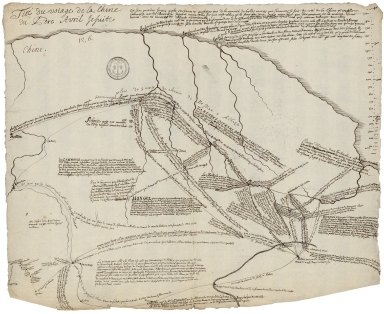
Tiré du voiage de la Chine du Pere Avril Jesuite.
|
|
Other Title:
|
Tiré du voyage de la Chine du Pére Avril Jésuite
|
|
Category:
|
General Maps
|
|
Type:
|
Manuscript
|
|
Language:
|
French
|
|
Create Year:
|
[173-]
|
|
Scale:
|
Scale indeterminable.
|
|
Physical Map Dimension (cm):
|
31 x 39 cm, on sheet 36 x 44 cm
|
|
Note:
|
This is very heavily annotated map with the travels of the French Jesuit Philippe Avril (1654-1698), sent to discover a safe overland route to China through Siberia. Leaving France, Avril arrived in the Middle East, and then traveled through Persia, the Caspian Sea, and the Volga to Moscow. He considered crossing Russian Siberia to the Chinese border next, but the Tsarist government, determined to deny foreigners access to, as well as knowledge of, his growing Asian empire blocked his route. Despite this setback, after his return to France, Avril published a report of great importance for the geographical knowledge of his time. He gave a scrupulous account of the countries he crossed; moreover, he was among the first to distinguish central Asia from northern Asia. For Westerners, the book by April provided one of the first descriptions of the geography and people of Siberia, and the various routes to China used by Russian merchants and explorers. Although he did not cross the Great Tartary himself, Avril painted a part of Asia little known to Westerners until then.
|
|
Note:
|
Original is a manuscript map.
|
|
Note:
|
Vertical scale line on the right upper corner of the map.
|
|
Subject:
|
Travel
|
|
Geographic Area:
|
Asia
|
|
Geographic Area:
|
Mongolia
|
|
Geographic Area:
|
Russia
|
|
Geographic Area:
|
China
|
|
Provenance:
|
Archives Nationales de France
|
|
Provenance Call No.:
|
MAP/6JJ/74/A/20
|
|
MUST holding:
|
https://must.primo.exlibrisgroup.com/permalink/853MUST_INST/171sgkf/alma991003000349705076
|