Detail View: Old Maps Collection: Nova totius terrarum orbis geographica ac hydrographica tabula
|
Barcode:
|
3687800285610B
|
|
Title:
|
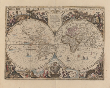
Nova totius terrarum orbis geographica ac hydrographica tabula
|
|
Contributor:
|
Huys, François, a. 1603-1661, engraver
|
|
Contributor:
|
Jonghe, Clement de, ca. 1624-1677, printer
|
|
Category:
|
World Map
|
|
Type:
|
Printed
|
|
Language:
|
Latin
|
|
Language:
|
Portuguese
|
|
Language:
|
Spanish
|
|
Language:
|
Dutch
|
|
Create Year:
|
1664
|
|
Page No.:
|
2
|
|
Scale:
|
Scale not given.
|
|
Physical Map Dimension (cm):
|
41 x 55 cm, on sheet 68 x 92 cm
|
|
Note:
|
This double hemisphere map was first published by Jodocus Hondius ca. 1625 and the first printed map to include the Dutch discoveries on the West Coast of Australia -five places named. Many maps were later printed according to this Hondius model including this one in the book 'Le grand nouvel atlas de le mer, ou Monde aquatique' by Johannes van Keulen. The usual Southern Continent completely disappears on this map and North America is not as wide as commonly found on early 17th century maps. California is shown correctly as a peninsula. As for South America still includes the two mythical lakes -the here unnamed 'Lake Parime' underneath the city of 'Manoa' or 'El Dorado' and 'Lacus E[n]pana' in Brazil. On Asia, Korea is still depicted as an island and only the northern coast of New Guinea is depicted. Macao is written on land on the eastern side of the Pearl River estuary.
|
|
Note:
|
Original is a copper printed map hand colored published in the work 'Le grand nouvel atlas de le mer, ou Monde aquatique' by Johannes van Keulen, 39 x 56 cm.
|
|
Note:
|
There is a full compass rose on the East hemisphere and a half compass rose on the West hemisphere. Both are colored red and yellow. The half-winds for both of them are dotted and curved which some authors believe to be an early attempt on isolines. On total are depicted 8 vessels and two sea monsters. At the middle of the two hemispheres on the upper part there is a cartouche with the imprint sided by the representations of Earth -Terra- with a cornucopia on her left hand and of Water -Aqua- with a river filled with fish and a jar in hand spilling water to the ocean. Also at the center but on the bottom there is a celestial globe with the name of the engraver of the map -'Franscoiis Huiis'- sided by representations of Fire -Ignis- with flames surrounding his head, stepping on a dragon and a volcano on the horizon and Air -Aer- sitting on a cloud with winds heads, together with some birds. On each corner there is the representations of the four seasons: Spring -Ver- as a woman with a leafed branch in hand with a field on the background being planted; Summer -Aestas- as a woman accompanied by two child, harvest tools and the killing of animals on the background; Autumn -Autumnus- as a man with some fruits on his back and a stepping on the grapes scene behind him and finally Winter -Hyems- as a man eating by the fire with people skying on a frozen lake on the further-ground.
|
|
Note:
|
Continents outlined in different colours.
|
|
Note:
|
Equator line in black and white interchangeably.
|
|
Note:
|
Map outlined in dash-doted border.
|
|
Note:
|
Macao in world maps.
|
|
Note:
|
Title, legends, land masses, water masses, Equator and Tropics in Latin with place names in Portuguese, Spanish and Dutch.
|
|
Reference:
|
Shirley, R.W. The mapping of the world: Early printed world maps 1472-1700 , 312
|
|
Reference:
|
Moreland, C. Antique maps, p. 102-103
|
|
Subject:
|
World Maps
|
|
Geographic Area:
|
World
|
|
Relation Note:
|
[pl. 2]
|
|
Pub Title:
|
Le grand nouvel atlas de le mer, ou Monde aquatique.
|
|
Pub Author:
|
Keulen, Johannes van, 1654-1715
|
|
Pub Year:
|
1682
|
|
Pub location:
|
A Amsterdam
|
|
Provenance:
|
Harvard College Library
|
|
Provenance:
|
http://id.lib.harvard.edu/alma/990058102810203941/catalog
|
|
Provenance Call No.:
|
GEN MA 17.82.2 pf*
|
|
MUST holding:
|
https://must.primo.exlibrisgroup.com/permalink/853MUST_INST/171sgkf/alma991000058799705076
|