Detail View: Old Maps Collection: Far East and Insulindia
|
Barcode:
|
3687800354452C
|
|
Title:
|
Far East and Insulindia
|
|
Original Title:
|
[Extremo Oriente e Insulíndia]
|
|
Contributor:
|
Dourado, Fernão Vaz, 1520-1580, cartographer
|
|
Contributor:
|
Ferron, cavalheiro, former owner
|
|
Contributor:
|
Carlos I, King of Portugal, 1863-1908, former owner
|
|
Contributor:
|
Castelo Branco, João Martens Ferrão de, fl. 1847-1891, former owner
|
|
Category:
|
Atlas
|
|
Type:
|
Printed
|
|
Language:
|
Portuguese
|
|
Language:
|
Latin
|
|
Create Year:
|
[ca. 1576]
|
|
Page No.:
|
12
|
|
Scale:
|
Scale not given.
|
|
Physical Map Dimension (cm):
|
38 x 51 cm, on sheet 39 x 54 cm
|
|
Note:
|
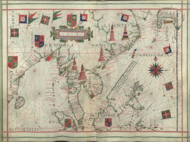
Fernão Vaz Dourado has always been considered a great cartographer and has been called by some authors the most famous and remarkable 16th century Portuguese cartographer. His works will always be outstanding for the artistic beauty of its illumination. The Atlas in which this map is inserted was probably made in 1576, most probably in Lisbon. It is from a series of other several similar Atlases, being the earliest one from 1568. This Atlas its not signed or dated and has no frontispiece. And even though the drawing and illumination are still very beautiful it is definitely below the standard of the other five atlases. This map includes a key early depiction of Japan, which later would be designated the 'Dourado type'. On the west side of Pearl River are marked 'Camtaö' and 'Camaö' which refers to Guangzhou and Jiangmen respectively.
|
|
Note:
|
The original is a manuscript Portolan Atlas of 20 l. on parchment, 39 x 28 cm. The Atlas has parchment leaves used on one side, folded in two in a leather binding. It belonged to a knight Ferron, ca. 1843; to João Martens Ferrão de Castelo Branco after 1847 and, before 1891, to the library of the Portuguese king D. Carlos I.
|
|
Note:
|
Title from the provenance library.
|
|
Note:
|
The map has five coats of arms, all stylizations of representations of Arabic nations; and ten banners, four of Portugal, two of Arabic nations, three of the Order of Christ and one of Spain. Important cities marked with illustrations of towers, one in Pegu -modern day Myanmar-, other in Cambodia and three in China. There is a 32-point compass rose in black, blue, red, green and gold with a fleur-de-lis indicating north. As for the rhumb lines, the principal winds are in black, the half-winds in green and the quarter-winds in red.
|
|
Note:
|
Table of leagues inside strapwork cartouche.
|
|
Note:
|
Area names in square capitals as for toponyms in black and red ink in minuscule script. Land masses outlined in green with small islands painted gold, red and blue.
|
|
Note:
|
Latitude line at the right side in gold and blue interchangeably.
|
|
Note:
|
Tropic of Cancer and Equator lines in red.
|
|
Note:
|
Map outlined in double line bordure in red and green.
|
|
Note:
|
Macao in East Indies Maps.
|
|
Note:
|
In Latin and Portuguese.
|
|
Reference:
|
Correia, F. Inventário da colecção dos manuscritos iluminados da Biblioteca Nacional, p. 61
|
|
Reference:
|
Cortesão, A. Portugalliae Monumenta Cartographica, vol. 3, p.29-32
|
|
Reference:
|
Cortesão, A. Cartografia e cartógrafos portugueses dos séculos XV e XVI
|
|
Subject:
|
Atlas
|
|
Geographic Area:
|
China
|
|
Geographic Area:
|
Japan
|
|
Geographic Area:
|
Korea
|
|
Geographic Area:
|
East Indies
|
|
Geographic Area:
|
Vietnam
|
|
Geographic Area:
|
Paracel Islands
|
|
Geographic Area:
|
Borneo
|
|
Geographic Area:
|
Philippines
|
|
Geographic Area:
|
Malaysia
|
|
Geographic Area:
|
India
|
|
Geographic Area:
|
Ceylon
|
|
Relation Note:
|
[f. 12]
|
|
Pub Title:
|
[Atlas].
|
|
Pub Author:
|
Dourado, Fernão Vaz, 1520-1580
|
|
Pub Year:
|
[ca. 1576]
|
|
Pub location:
|
[S.l.]
|
|
Provenance:
|
Biblioteca Nacional de Portugal
|
|
Provenance:
|
http://id.bnportugal.gov.pt/bib/catbnp/560863
|
|
Provenance Call No.:
|
IL. 171.
|
|
MUST holding:
|
https://must.primo.exlibrisgroup.com/permalink/853MUST_INST/171sgkf/alma991002999349705076
|