Detail View: Old Maps Collection: Map of Tartaria or the kingdom of the great Cham
|
Barcode:
|
3687800354453D
|
|
Title:
|
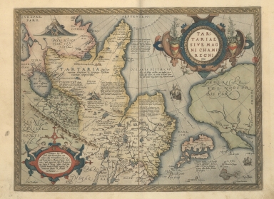
Map of Tartaria or the kingdom of the great Cham
|
|
Original Title:
|
Tartariae sive magni Chami regni tӱpus
|
|
Contributor:
|
Ortelius, Abraham, 1527-1598, author
|
|
Category:
|
Atlas
|
|
Type:
|
Printed
|
|
Language:
|
Latin
|
|
Language:
|
Portuguese
|
|
Language:
|
Spanish
|
|
Language:
|
Italian
|
|
Create Year:
|
[1571]
|
|
Page No.:
|
47
|
|
Scale:
|
[1:20,000,000].
|
|
Physical Map Dimension (cm):
|
35 x 47 cm, on sheet 42 x 55 cm
|
|
Note:
|
Abraham Ortelius published in 1571 in Antwerp the reputed first modern atlas 'Theatrum Orbis Terrarum'. It contains originally 53 maps later updated continuously by Ortelius in 'Additamenti' until his death in 1598. By 1612 the atlas had already 31 editions in many languages. This map depicts Tartary, Japan, and the west coast of North America and just like many others of Ortelius' maps, it was innovative for its time. It is one of the earliest map to include the Strait of Anian, which separates North America and Asia. Today the Bering Strait, Anian derives from Ania, a Chinese province on a large gulf mentioned in Marco Polo’s travels which was in fact the Gulf of Tonkin -somehow transposed over time from Vietnam to the northwest coast of North America. It appeared on maps until mid 18th century. On the map can be seen quite a number of legends, even though the information is mostly imaginary. But they also reveal some of Ortelius' sources, Prester John, Marco Polo, and the Bible, always an important source for European mapmakers. The map also includes a remarkable early treatment of the Northwest Coast of America, with California.
|
|
Note:
|
Original map is from the atlas 'Theatrum Orbis Terrarum' from Abraham Ortelius copperplate printed in 1571 and hand colored. The atlas has 53 maps.
|
|
Note:
|
On Tartary are depicted seven Tartar yurt tents, two of them with kings seated on thrones at the entrance of the tents. There are two European sail ships on water and a sea monster.
|
|
Note:
|
Title inside strapwork cartouche on the upper right corner of the map sided by phytomorphic motives. Legend inside strapwork cartouche on the left bottom corner of the map sided by Adam and Eve, headed by two birds a fleur-de-lis.
|
|
Note:
|
The upper, right and left borders of the map labelled with North, East and West in Latin Septentrio (Septentriones), Oriens and Occidens respectively.
|
|
Note:
|
Map with graticule.
|
|
Note:
|
Land masses in different colors.
|
|
Note:
|
Relief is shown pictorially.
|
|
Note:
|
Map inside yellow scroll work border.
|
|
Note:
|
Title, scale, privilege and land and water masses in Latin with place names in Portuguese, Spanish and Italian.
|
|
Reference:
|
Cartographica Neerlandica http://www.orteliusmaps.com/book/ort163.html
|
|
Subject:
|
Atlas
|
|
Geographic Area:
|
China
|
|
Geographic Area:
|
Taiwan
|
|
Geographic Area:
|
Japan
|
|
Geographic Area:
|
Mongolia
|
|
Geographic Area:
|
Russia
|
|
Geographic Area:
|
North America
|
|
Relation Note:
|
[47]
|
|
Pub Title:
|
[Theatrum Orbis Terrarum].
|
|
Pub Author:
|
Ortelius, Abraham, 1527-1598
|
|
Pub Year:
|
1571
|
|
Pub location:
|
Antuerpiae
|
|
Provenance:
|
Biblioteca Nacional de Portugal
|
|
Provenance:
|
http://id.bnportugal.gov.pt/bib/catbnp/279930
|
|
Provenance Call No.:
|
C.A. 117 V.
|
|
MUST holding:
|
https://must.primo.exlibrisgroup.com/permalink/853MUST_INST/171sgkf/alma991002999349805076
|