Detail View: Old Maps Collection: Carte des Isles Philippines : dressée sur la carte espagnole du R.P. Murillo de Velarde I.re feville
|
Barcode:
|
3687800354454E
|
|
Title:
|
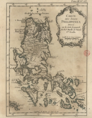
Carte des Isles Philippines : dressée sur la carte espagnole du R.P. Murillo de Velarde I.re feville
|
|
Contributor:
|
Bellin, Jacques-Nicolas, 1703-1772, cartographer
|
|
Contributor:
|
Murillo Velarde, Pedro, 1696-1753, bibliographic antecedent
|
|
Category:
|
Atlas
|
|
Type:
|
Printed
|
|
Language:
|
French
|
|
Language:
|
Portuguese
|
|
Language:
|
Spanish
|
|
Create Year:
|
[1764]
|
|
Page No.:
|
65
|
|
Scale:
|
Scale indeterminable.
|
|
Physical Map Dimension (cm):
|
21 x 15 cm, on sheet 29 x 22 cm
|
|
Note:
|
This map depicts the Philippines extending from Batanes and Babuyans to Mindoro and Masbate, and centered on Luzon. One of the most detailed maps of the archipelago at the time.
|
|
Note:
|
Original is a copperplate printed map in the 'Le petit atlas maritime: recueil de cartes et plans des quatre parties du monde'.
|
|
Note:
|
Title inside scroll work cartouche.
|
|
Note:
|
Scale line underneath the title in black and white interchangeably.
|
|
Note:
|
Relief shown pictorially.
|
|
Note:
|
Latitude line on the left border of the map and longitude lines on the top and bottom borders of the map in black and white interchangeably.
|
|
Note:
|
Landmasses outlined in green.
|
|
Note:
|
Map outlined in simple fillet.
|
|
Note:
|
Title and scale line in French with some place names in French, Portuguese and Spanish.
|
|
Reference:
|
Phillips, P.L. A list of geographical atlases in the Library of Congress, vol. 3, n.º 3508, p. 348-355
|
|
Subject:
|
Atlas
|
|
Geographic Area:
|
Philippines
|
|
Relation Note:
|
Tome III, n.º 65
|
|
Pub Title:
|
Petit atlas maritime : recueil de cartes et plans des quatre parties du monde.
|
|
Pub Author:
|
Bellin, Jacques-Nicolas, 1703-1772
|
|
Pub Year:
|
1764
|
|
Pub location:
|
[Paris]
|
|
Provenance:
|
Biblioteca Nacional de Portugal
|
|
Provenance:
|
http://id.bnportugal.gov.pt/bib/catbnp/604917
|
|
Provenance Call No.:
|
C.A. 62 V.
|
|
MUST holding:
|
https://must.primo.exlibrisgroup.com/permalink/853MUST_INST/171sgkf/alma991002999249505076
|