Detail View: Old Maps Collection: Cambodia, Siam, Borneo, Papua New Guinea
|
Barcode:
|
3687800354455F
|
|
Title:
|
Cambodia, Siam, Borneo, Papua New Guinea
|
|
Original Title:
|
[Camboja, Sião, Borneo, Nova Guiné]
|
|
Contributor:
|
Dourado, Fernão Vaz, 1520-1580, cartographer
|
|
Contributor:
|
Ferron, cavalheiro, former owner
|
|
Contributor:
|
Carlos I, King of Portugal, 1863-1908, former owner
|
|
Contributor:
|
Castelo Branco, João Martens Ferrão de, fl. 1847-1891, former owner
|
|
Category:
|
Atlas
|
|
Type:
|
Manuscript
|
|
Language:
|
Portuguese
|
|
Create Year:
|
[ca. 1576]
|
|
Page No.:
|
13
|
|
Scale:
|
Scale not given.
|
|
Physical Map Dimension (cm):
|
39 x 52 cm, on sheet 43 x 56 cm
|
|
Note:
|
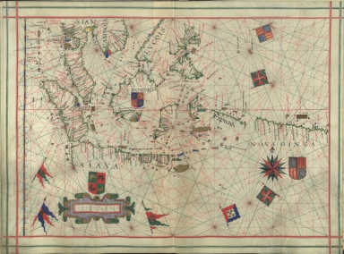
Fernão Vaz Dourado has always been considered a great cartographer and has been called by some authors the most famous and remarkable 16th century Portuguese cartographer. His works will always be outstanding for the artistic beauty of its illumination. The Atlas in which this map is inserted was probably made in 1576, most probably in Lisbon. It is from a series of other several similar Atlases, being the earliest one from 1568. This Atlas its not signed or dated and has no frontispiece. And even though the drawing and illumination are still very beautiful it is definitely below the standard of the other five atlases. On this particular map the Strait of Malacca is already depicted quite detailed, however, Borneo, Java, Papua New Guinae and even the Philippines are still unfinished denoting the territories were just then being discovered. Part of Luzon is depicted in a straight line, later also used by Luís Barbuda on his China map published in Ortelius' 'Theatrum Orbis Terrarum'; only the northern part of Java is portrayed, even though with quite a number of toponyms; and the west part of Borneo. Papua New Guinea is not so rich on toponyms as Java and appears in a very primitive stage of portrayal.
|
|
Note:
|
The original is a manuscript Portolan Atlas of 20 l. on parchment, 39 x 28 cm. The Atlas belonged to a knight Ferron, ca. 1843; to João Martens Ferrão de Castelo Branco after 1847 and, before 1891, to the library of the Portuguese king D. Carlos I.
|
|
Note:
|
Title from the provenance library.
|
|
Note:
|
The map has three coats of arms, two of stylizations of representations of Arabic nations and one of Spain. There are also seven banners, one of Portugal, three of Arabic nations, two of the Order of Christ and one of Spain. A 32-point compass rose in black, blue, red, green and gold with a fleur-de-lis indicating north. As for the rhumb lines, the principal winds are in black, the half-winds in green and the quarter-winds in red.
|
|
Note:
|
Table of leagues inside strapwork cartouche on the left bottom side of the map.
|
|
Note:
|
Area names in square capitals as for toponyms in black and red ink in minuscule script. Land masses outlined in green with small islands painted gold, red and blue.
|
|
Note:
|
Latitude line at the left side in gold and blue interchangeably.
|
|
Note:
|
Equator line in red.
|
|
Note:
|
Map outlined in double line bordure in red and green.
|
|
Reference:
|
Correia, F. Inventário da colecção dos manuscritos iluminados da Biblioteca Nacional, p. 61
|
|
Reference:
|
Cortesão, A. Portugalliae Monumenta Cartographica, vol. 3, p. 29-32
|
|
Reference:
|
Cortesão, A. Cartografia e cartógrafos portugueses dos séculos XV e XVI
|
|
Subject:
|
Atlas
|
|
Geographic Area:
|
East Indies
|
|
Geographic Area:
|
Cambodia
|
|
Geographic Area:
|
Thailand
|
|
Geographic Area:
|
Paracel Islands
|
|
Geographic Area:
|
Borneo
|
|
Geographic Area:
|
Philippines
|
|
Geographic Area:
|
Malaysia
|
|
Geographic Area:
|
Papua New Guinea
|
|
Relation Note:
|
[f. 13]
|
|
Pub Title:
|
[Atlas]
|
|
Pub Author:
|
Dourado, Fernão Vaz, 1520-1580
|
|
Pub Year:
|
[ca. 1576]
|
|
Pub location:
|
[S.l.]
|
|
Provenance:
|
Biblioteca Nacional de Portugal
|
|
Provenance:
|
http://id.bnportugal.gov.pt/bib/catbnp/560863
|
|
Provenance Call No.:
|
IL. 171.
|
|
MUST holding:
|
https://must.primo.exlibrisgroup.com/permalink/853MUST_INST/171sgkf/alma991002999349605076
|