Detail View: Old Maps Collection: A Map of the 15 Provinces and 155 Capital Cities of the Chinese Empire
|
Barcode:
|
3687800354457H
|
|
Title:
|
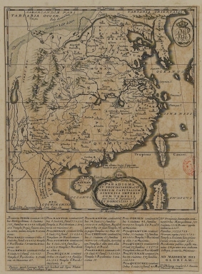
A Map of the 15 Provinces and 155 Capital Cities of the Chinese Empire
|
|
Original Title:
|
Paradigma XV Provinciarum et CLV Urbium capitalium Sinensis Imperij
|
|
Other Title:
|
Paradigma XV Provinciarum et CLV Urbium capitalium Sinensis Imperii : cum templis quae cruce ⨁ signantur et domiciliis S.I.
|
|
Contributor:
|
Couplet, Philippe, 1623-1692, cartographer
|
|
Contributor:
|
Louvemont, François de, 1648-ca. 1690, engraver
|
|
Contributor:
|
Nolin, Jean-Baptiste, 1648-1708, printer
|
|
Category:
|
Atlas
|
|
Type:
|
Printed
|
|
Language:
|
Latin
|
|
Create Year:
|
[1686]
|
|
Page No.:
|
1
|
|
Scale:
|
Scale indeterminable.
|
|
Physical Map Dimension (cm):
|
15 x 11 cm, on sheet 21 x 18 cm
|
|
Note:
|
Philippe Couplet was a Jesuit priest who entered the Society on 11th October 1640 and was ordained on 25th November 1654. He was inspired to undertake his mission to China after hearing a speech given by Martino Marini in Leuven in 1654. He departed for China two years later and arrived in 1659. He worked in the provinces of Jiangxi, Fujian, Huguang, Zhejiang, Nanking and Suzhou, before being exiled to Guangzhou with most other missionaries in 1665. In 1680, Couple was appointed procurator of the Chinese Vice-Province and sent to Rome. He left Macau on December 5, 1681 and reached Europe on October 8, 1682. Ferdinand Verbiest had charged him to get French Jesuits for the China mission, as only Portuguese Jesuits or those who worked for Portugal had been in China. This map depicts China's 15 provinces and 155 major cities, and notes the location of the discovery of the Nestorian Stele in Shaanxi Province as well as the island where St. Francis Xavier died in Southern China. The cross next to a toponym marks the presence of a Christian Mission. The table underneath the map provide additional information by listing cities, settlements, families, temples and missionaries, etc. in each Province. This map is a statement of the influence of the Jesuit Faith in China at this time.
|
|
Note:
|
Original is a copperplate printed map in the '[Novus Atlas Sinensis]', 23 x 21 cm, on sheet 29 x 21 cm.
|
|
Note:
|
On the left bottom corner of the map: "Franc. de Louvemont sculp."
|
|
Note:
|
Title inside phytomorphic cartouche headed by the monogram of the Society of Jesus.
|
|
Note:
|
Scale line underneath the title in black and white interchangeably.
|
|
Note:
|
Relief shown pictorially.
|
|
Note:
|
Tropic of Cancer in double line.
|
|
Note:
|
Map with graticule.
|
|
Note:
|
The four borders of the map with latitude and longitude lines in black and white interchangeably.
|
|
Note:
|
Map outlined in simple fillet.
|
|
Note:
|
Macao in China maps.
|
|
Subject:
|
Atlas
|
|
Geographic Area:
|
China
|
|
Geographic Area:
|
Hainan Island (China)
|
|
Geographic Area:
|
Taiwan
|
|
Geographic Area:
|
Korea
|
|
Geographic Area:
|
Philippines
|
|
Relation Note:
|
[Pl. 1]
|
|
Pub Title:
|
[Novus Atlas Sinensis].
|
|
Pub Author:
|
Martini, Martino, 1614-1661
|
|
Pub Year:
|
[1686]
|
|
Pub location:
|
[Amsterdam]
|
|
Provenance:
|
Biblioteca Nacional de Portugal
|
|
Provenance:
|
http://id.bnportugal.gov.pt/bib/catbnp/554951
|
|
Provenance Call No.:
|
C.A. 70 A.
|
|
MUST holding:
|
https://must.primo.exlibrisgroup.com/permalink/853MUST_INST/171sgkf/alma991002999249405076
|