Detail View: Old Maps Collection: Particular map of a part of the coast of China with the island of Pakas and surrounding islands, up to the southernmost part of Japan
|
Barcode:
|
3687800354459J
|
|
Title:
|
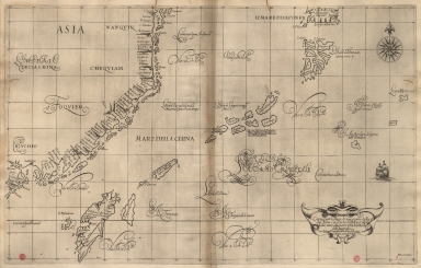
Particular map of a part of the coast of China with the island of Pakas and surrounding islands, up to the southernmost part of Japan
|
|
Original Title:
|
Carta particolare d'una parte della co.ta di China con l'Isola di Pakas è altre isole, sino alla parte piu Australe del'Giapone
|
|
Other Title:
|
Carta particolare di una parte della costa di China con l'Isola di Pakas è altre isole, sino alla parte piu Australe del'Giappone
|
|
Contributor:
|
Dudley, Robert, Sir, 1574-1649, cartographer
|
|
Contributor:
|
Lucini, Antonio Francesco, 1605-1640, engraver
|
|
Contributor:
|
Onofri, Francesco, fl. 1631-1679, printer
|
|
Category:
|
Atlas
|
|
Type:
|
Printed
|
|
Language:
|
Italian
|
|
Language:
|
Portuguese
|
|
Language:
|
Spanish
|
|
Create Year:
|
[1647]
|
|
Page No.:
|
16
|
|
Scale:
|
Scale indeterminable ; Mercator proj.
|
|
Physical Map Dimension (cm):
|
48 x 76 cm, on sheet 53 x 79 cm
|
|
Note:
|
Robert Dudley was the illegitimate son of Robert Dudley, 1st Earl of Leicester. In 1594, Dudley led an expedition to the West Indies, of which he wrote an account. After unsuccessfully trying to establish his legitimacy in court, he left England and converted to Catholicism, taking up residence in Florence where he served the Grand Dukes of Tuscany in their efforts to rid the Mediterranean of Piracy. There he worked as a noted shipbuilder and designed and published the work 'Dell'Arcano del Mare', the first maritime atlas to cover the whole world, the first Sea Atlas published by and Englishman and the first atlas to utilize the Mercator Projection on a uniform basis. Its inclusion of winds and currents was also a monumental first. This is a map of the China Sea that includes the southeast part of the coast of China, the Island of Taiwan, the southwest part of Kyushu and the islands of Okinawa, though not accurately represented.
|
|
Note:
|
Original is a copperplate printed map in the second part of the third volume of '[Dell'Arcano del Mare]'.
|
|
Note:
|
On the right bottom corner of the map: "A.F. Lucini fece."
|
|
Note:
|
Underneath the title: "La longitu.ne comin.ca da l'Isola di Pico d'Asores."
|
|
Note:
|
There is a sail ship on the Philippine Sea. A 32-point compass rose is on the map with a fleur-de-lis indicating north.
|
|
Note:
|
Title inside strapwork cartouche.
|
|
Note:
|
Tropic of Cancer in double line.
|
|
Note:
|
Map with graticule.
|
|
Note:
|
Title and notes in Italian with place names in Italian, Portuguese and Spanish.
|
|
Reference:
|
Tooley's dictionary of mapmakers, p. 395
|
|
Reference:
|
Phillips, vol. 1, n.o 456, p. 203-216
|
|
Subject:
|
Atlas
|
|
Geographic Area:
|
China
|
|
Geographic Area:
|
Japan
|
|
Geographic Area:
|
Korea
|
|
Geographic Area:
|
Taiwan
|
|
Relation Note:
|
D'Asia carta XVI
|
|
Pub Title:
|
[Dell'Arcano del Mare].
|
|
Pub Author:
|
Dudley, Robert, Sir, 1574-1649
|
|
Pub Year:
|
[1647]
|
|
Pub location:
|
[In Firenze]
|
|
Provenance:
|
Biblioteca Nacional de Portugal
|
|
Provenance:
|
http://id.bnportugal.gov.pt/bib/catbnp/279649
|
|
Provenance Call No.:
|
C.A. 131 A.
|
|
MUST holding:
|
https://must.primo.exlibrisgroup.com/permalink/853MUST_INST/171sgkf/alma991002998949305076
|