Detail View: Old Maps Collection: Particular map of the sea of Cochinchina with the southern part of China
|
Barcode:
|
3687800354464F
|
|
Title:
|
Particular map of the sea of Cochinchina with the southern part of China
|
|
Original Title:
|
Carta particolare del'mare di Cocincina con la parte Australe della China
|
|
Other Title:
|
Carta particolare del mare di Cocincina con la parte Australe della China
|
|
Contributor:
|
Dudley, Robert, Sir, 1574-1649, cartographer
|
|
Contributor:
|
Lucini, Antonio Francesco, 1605-1640, engraver
|
|
Contributor:
|
Onofri, Francesco, fl. 1631-1679, printer
|
|
Category:
|
Atlas
|
|
Type:
|
Printed
|
|
Language:
|
Italian
|
|
Language:
|
Portuguese
|
|
Language:
|
Spanish
|
|
Create Year:
|
[1647]
|
|
Page No.:
|
7
|
|
Scale:
|
Scale indeterminable ; Mercator proj.
|
|
Physical Map Dimension (cm):
|
46 x 28 cm, on sheet 56 x 42 cm
|
|
Note:
|
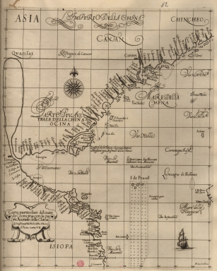
Robert Dudley was the illegitimate son of Robert Dudley, 1st Earl of Leicester. In 1594, Dudley led an expedition to the West Indies, of which he wrote an account. After unsuccessfully trying to establish his legitimacy in court, he left England and converted to Catholicism, taking up residence in Florence where he served the Grand Dukes of Tuscany in their efforts to rid the Mediterranean of Piracy. There he worked as a noted shipbuilder and designed and published the work 'Dell'Arcano del Mare', the first maritime atlas to cover the whole world, the first Sea Atlas published by and Englishman and the first atlas to utilize the Mercator Projection on a uniform basis. Its inclusion of winds and currents was also a monumental first. This is a map of the South China Sea with parts of the coasts of China and Vietnam, with Hainan Island (Tincous) and the Paracels. many of the islands on the map are not marked, however, a lot of toponyms can be seen on the mouth of the Peral River denoting it's importance. Macao appears two times on the map, one on each side of the Pearl River Estuary, as Macao city and Island of Macao; once again a statement of the importance of the place.
|
|
Note:
|
Original is a copperplate printed map in the second part of the third volume of '[Dell'Arcano del Mare]'.
|
|
Note:
|
On the right bottom corner of the map: "A.F. Lucini fece."
|
|
Note:
|
Underneath the title: "La longitu.ne comin.ca da l'Isola di Pico d'Asores."
|
|
Note:
|
There is a sail ship on the South China Sea. A 32-point compass rose is on the map with a fleur-de-lis indicating north.
|
|
Note:
|
Title inside strapwork cartouche.
|
|
Note:
|
Relief shown pictorially and bathymetric relief by soundings.
|
|
Note:
|
Tropic of Cancer in double line.
|
|
Note:
|
Map with graticule.
|
|
Note:
|
Macao in China maps.
|
|
Note:
|
Title and notes in Italian with place names in Italian, Portuguese and Spanish.
|
|
Reference:
|
Tooley's dictionary of mapmakers, p. 395
|
|
Reference:
|
Phillips, vol. 1, n.o 456, p. 203-216
|
|
Subject:
|
Atlas
|
|
Geographic Area:
|
South China Sea
|
|
Geographic Area:
|
China
|
|
Geographic Area:
|
Vietnam
|
|
Geographic Area:
|
Hainan Island (China)
|
|
Geographic Area:
|
Paracel Islands
|
|
Relation Note:
|
D'Asia carta VII
|
|
Pub Title:
|
[Dell'Arcano del Mare].
|
|
Pub Author:
|
Dudley, Robert, Sir, 1574-1649
|
|
Pub Year:
|
[1647]
|
|
Pub location:
|
[In Firenze]
|
|
Provenance:
|
Biblioteca Nacional de Portugal
|
|
Provenance:
|
http://id.bnportugal.gov.pt/bib/catbnp/279649
|
|
Provenance Call No.:
|
C.A. 131 A.
|
|
MUST holding:
|
https://must.primo.exlibrisgroup.com/permalink/853MUST_INST/171sgkf/alma991002999649405076
|