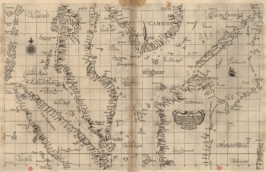
Detail View: Old Maps Collection: Particular map of Malacca with the coast from Pegu, Cambodia with the Islands of Sumatra and northern part of Borneo many other surrounding islands and islets
|
Barcode:
|
3687800354466H
|
|
Title:
|
Particular map of Malacca with the coast from Pegu, Cambodia with the Islands of Sumatra and northern part of Borneo many other surrounding islands and islets
|
|
Original Title:
|
Carta particolare della Malacca con la costa sin' al Peguè Camboia con l'Isole di Sumatra è Burneo parte Tramontana con molte altre Isole è Iso.te in tor[n]o
|
|
Other Title:
|
Carta particolare della Malacca con la costa sin' al Peguè Camboia con l'Isole di Sumatra è Burneo parte Tramontana con molte altre Isole è Isolette intorno
|
|
Contributor:
|
Dudley, Robert, Sir, 1574-1649, cartographer
|
|
Contributor:
|
Lucini, Antonio Francesco, 1605-1640, engraver
|
|
Contributor:
|
Onofri, Francesco, fl. 1631-1679, printer
|
|
Category:
|
Atlas
|
|
Type:
|
Printed
|
|
Language:
|
Italian
|
|
Language:
|
Portuguese
|
|
Language:
|
Spanish
|
|
Create Year:
|
[1647]
|
|
Page No.:
|
6
|
|
Scale:
|
Scale indeterminable ; Mercator proj.
|
|
Physical Map Dimension (cm):
|
48 x 75 cm, on sheet 59 x 82 cm
|
|
Note:
|
Robert Dudley was the illegitimate son of Robert Dudley, 1st Earl of Leicester. In 1594, Dudley led an expedition to the West Indies, of which he wrote an account. After unsuccessfully trying to establish his legitimacy in court, he left England and converted to Catholicism, taking up residence in Florence where he served the Grand Dukes of Tuscany in their efforts to rid the Mediterranean of Piracy. There he worked as a noted shipbuilder and designed and published the work 'Dell'Arcano del Mare', the first maritime atlas to cover the whole world, the first Sea Atlas published by and Englishman and the first atlas to utilize the Mercator Projection on a uniform basis. Its inclusion of winds and currents was also a monumental first. This is a map of the Strait of Malacca with the southern part of Vietnam and northern part of Borneo. The surrounding islands and islets and shoals are drawn quite detailed both on the strait and on the South China Sea.
|
|
Note:
|
Original is a copperplate printed map in the second part of the third volume of '[Dell'Arcano del Mare]'.
|
|
Note:
|
On the left bottom corner of the map: "A.F. Lucini fece."
|
|
Note:
|
Underneath the title: "La longitu.ne comin.ca da l'Isola di Pico d'Asores."
|
|
Note:
|
There is a sail ship on the South China Sea. A 32-point compass rose is on the map with a fleur-de-lis indicating north.
|
|
Note:
|
Title inside strapwork cartouche.
|
|
Note:
|
Equator in double line.
|
|
Note:
|
Map with graticule.
|
|
Note:
|
Title and notes in Italian with place names in Italian, Portuguese and Spanish.
|
|
Reference:
|
Tooley's dictionary of mapmakers, p. 395
|
|
Reference:
|
Phillips, vol. 1, n.o 456, p. 203-216
|
|
Subject:
|
Atlas
|
|
Geographic Area:
|
South China Sea
|
|
Geographic Area:
|
China
|
|
Geographic Area:
|
Vietnam
|
|
Geographic Area:
|
Malacca (Malacca, Malaysia)
|
|
Geographic Area:
|
Sumatra (Indonesia)
|
|
Geographic Area:
|
Borneo
|
|
Geographic Area:
|
Philippines
|
|
Geographic Area:
|
Paracel Islands
|
|
Relation Note:
|
D'Asia carta VI
|
|
Pub Title:
|
[Dell'Arcano del Mare].
|
|
Pub Author:
|
Dudley, Robert, Sir, 1574-1649
|
|
Pub Year:
|
[1647]
|
|
Pub location:
|
[In Firenze]
|
|
Provenance:
|
Biblioteca Nacional de Portugal
|
|
Provenance:
|
http://id.bnportugal.gov.pt/bib/catbnp/279649
|
|
Provenance Call No.:
|
C.A. 131 A.
|
|
MUST holding:
|
https://must.primo.exlibrisgroup.com/permalink/853MUST_INST/171sgkf/alma991002999649305076
|