Detail View: Old Maps Collection: Asia carta di ciasete piu moderna
|
Barcode:
|
3687800354467I
|
|
Title:
|
Asia carta di ciasete piu moderna
|
|
Contributor:
|
Dudley, Robert, Sir, 1574-1649, cartographer
|
|
Contributor:
|
Lucini, Antonio Francesco, 1605-1640, engraver
|
|
Contributor:
|
Onofri, Francesco, fl. 1631-1679, printer
|
|
Category:
|
Atlas
|
|
Type:
|
Printed
|
|
Language:
|
Italian
|
|
Language:
|
Portuguese
|
|
Language:
|
Spanish
|
|
Create Year:
|
[1646]
|
|
Page No.:
|
52
|
|
Scale:
|
Scale indeterminable ; Mercator proj.
|
|
Physical Map Dimension (cm):
|
48 x 75 cm, on sheet 55 x 79 cm
|
|
Note:
|
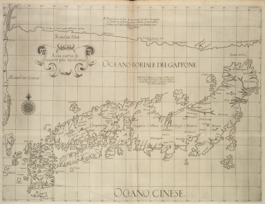
Robert Dudley was the illegitimate son of Robert Dudley, 1st Earl of Leicester. In 1594, Dudley led an expedition to the West Indies, of which he wrote an account. After unsuccessfully trying to establish his legitimacy in court, he left England and converted to Catholicism, taking up residence in Florence where he served the Grand Dukes of Tuscany in their efforts to rid the Mediterranean of Piracy. There he worked as a noted shipbuilder and designed and published the work 'Dell'Arcano del Mare', the first maritime atlas to cover the whole world, the first Sea Atlas published by and Englishman and the first atlas to utilize the Mercator Projection on a uniform basis. Its inclusion of winds and currents was also a monumental first. This is the larger of two maps of Japan created by Dudley for his 'Dell' Arcano del Mare', loosely based on the Ortelius map of 1595, but with important changes and additions from the files of the Dutch East India Company. The map includes Japan and a portion of the Korean coast. Japan is depicted in the Teixeira-type but already depicts the island of Yezo (Hokkaido) even though very enlarged. Despite its more accurate mapping, Dudley's improvements went largely unnoticed except for a few changes included by Jansson some years later. For the improvements the Dudley relied mostly on the numerous published accounts of Missionaries but also unpublished Dutch charts.
|
|
Note:
|
Original is a copperplate printed map in the second part of the second volume of 'Dell'Arcano del Mare'.
|
|
Note:
|
On the right upper corner of the map: "A.F. Lucini fecit."
|
|
Note:
|
There is a 32-point compass rose is on the map with a fleur-de-lis indicating north.
|
|
Note:
|
Title inside strapwork cartouche.
|
|
Note:
|
Relief shown pictorially.
|
|
Note:
|
Map with graticule.
|
|
Note:
|
Title and notes in Italian with place names in Italian, Portuguese and Spanish.
|
|
Reference:
|
Tooley's dictionary of mapmakers, p. 395
|
|
Subject:
|
Early works to 1800
|
|
Geographic Area:
|
Japan
|
|
Geographic Area:
|
Korea
|
|
Relation Note:
|
Vol. 2, [p. 52]
|
|
Pub Title:
|
Dell'Arcano del Mare.
|
|
Pub Author:
|
Dudley, Robert, Sir, 1574-1649
|
|
Pub Year:
|
1646
|
|
Pub location:
|
Firenze
|
|
Provenance:
|
Harvard College Library
|
|
Provenance:
|
http://id.lib.harvard.edu/alma/990000041370203941/catalog
|
|
Provenance Call No.:
|
000004137
|
|
MUST holding:
|
https://must.primo.exlibrisgroup.com/permalink/853MUST_INST/171sgkf/alma991002999649205076
|