Detail View: Old Maps Collection: Planta da bacia geral dos rios Si-Kiang, Peh-Kiang e Han-Kiang ou rios do oeste, norte e de este desde a sua origem até desembocarem no mar da China pelos estuários de Cantão e do Broadway : extrahida da Planta da Provincia de Cantão levantada por J.G. Lörcher e completada pelas cartas da China de J. Perthes e de Williams. N. 1.
|
Barcode:
|
3687800354470C
|
|
Title:
|
Planta da bacia geral dos rios Si-Kiang, Peh-Kiang e Han-Kiang ou rios do oeste, norte e de este desde a sua origem até desembocarem no mar da China pelos estuários de Cantão e do Broadway : extrahida da Planta da Provincia de Cantão levantada por J.G. Lörcher e completada pelas cartas da China de J. Perthes e de Williams. N. 1.
|
|
Contributor:
|
Lörcher, J. G., Rev., bibliographic antecedent
|
|
Contributor:
|
Perthes, Justus, 1749-1816, bibliographic antecedent
|
|
Contributor:
|
Berghaus, Heinrich Karl Wilhelm, 1797-1884, bibliographic antecedent
|
|
Contributor:
|
Assunção, António José Saldanha, 1850-1900, lithographer
|
|
Contributor:
|
Macau. Imprensa Nacional, lithographer
|
|
Category:
|
General Maps
|
|
Type:
|
Printed
|
|
Language:
|
Portuguese
|
|
Create Year:
|
1884
|
|
Scale:
|
1:2,344,000.
|
|
Physical Map Dimension (cm):
|
39 x 62 cm, on sheet 49 x 68 cm
|
|
Note:
|
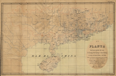
This map depicts the rivers of the Guangdong Province, focusing on the Xi River (Si-Kiang), Bei River (Peh-Kiang) and Han River (Han-Kiang) from spring to their disembogue by the Canton and Broadway estuaries. The area covered by said rivers is outlined in red. Also in red are Macao, Taipa, Coloane, D. João (Xiaohenqin) and Hong Kong, perhaps marking the foreign territories in China, even though D. João never really belonged to the Portuguese. The outline of the rivers in the Province, including also Hainan Island, are fairly detailed.
|
|
Note:
|
Original is a lithograph published in the work 'O Porto de Macau : ante-projecto para o seu melhoramento', 39 x 62 cm, on sheet 48 x 67 cm.
|
|
Note:
|
On the left bottom corner of the map: "Assumpção lith.". And on the right corner: "Lith. da I.sa N.al".
|
|
Note:
|
Map with graticule.
|
|
Note:
|
The four borders of the map with latitude and longitude lines.
|
|
Note:
|
Map outlined in double fillet.
|
|
Note:
|
Macao in China maps.
|
|
Subject:
|
General Maps
|
|
Geographic Area:
|
Guangdong Sheng (China)
|
|
Geographic Area:
|
Hainan Island (China)
|
|
Relation Note:
|
Estampa 1.ª
|
|
Pub Title:
|
Porto de Macau : ante-projecto para o seu melhoramento
|
|
Pub Author:
|
Loureiro, Adolfo Ferreira de, 1836-1911
|
|
Pub Year:
|
1884
|
|
Pub location:
|
Coimbra
|
|
Provenance:
|
Biblioteca Nacional de Portugal
|
|
Provenance:
|
http://id.bnportugal.gov.pt/bib/catbnp/478909
|
|
Provenance Call No.:
|
C.C. 697 A.
|
|
MUST holding:
|
https://must.primo.exlibrisgroup.com/permalink/853MUST_INST/171sgkf/alma991002998948605076
|