Detail View: Old Maps Collection: Korea, Northeast China, and South Japan
|
Barcode:
|
3687800354471D
|
|
Title:
|
Korea, Northeast China, and South Japan
|
|
Original Title:
|
Korea, Nordost-China, und Süd-Japan.
|
|
Other Title:
|
Map of Eastern China, Japan and Korea
|
|
Other Title:
|
[Peking].
|
|
Other Title:
|
[Tokio].
|
|
Other Title:
|
[Söul].
|
|
Contributor:
|
Carl Flemming (Firm), publisher
|
|
Category:
|
General Maps
|
|
Type:
|
Printed
|
|
Language:
|
German
|
|
Create Year:
|
[ca. 1894]
|
|
Scale:
|
1:4,500,000 (E 114°48ʹ00ʺ--E 140°49ʹ00ʺ/N 45°51ʹ00ʺ--N 30°23ʹ00ʺ).
|
|
Physical Map Dimension (cm):
|
34 x 46 cm, on sheet 46 x 53 cm
|
|
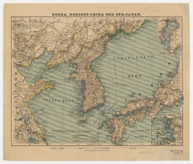
Note:
|
This is a map centered on the Korean Peninsula bordered with the Northeast coast of China on the left and upper side and part of Japan on the right. The map is of political interest as it was published at the outbreak of the First Sino-Japanese War.
|
|
Note:
|
Inset 1: [Peking]. - 1:1.000.000. - 4 x 5 cm. -- Inset 2: [Tokio]. - 1:1.000.000. - 10 x 7 cm. -- Inset 3: [Söul]. - 1:1.666.666. - 8 x 8 cm.
|
|
Note:
|
Original is a printed map, 35 x 45 cm.
|
|
Note:
|
Triple scale line on the bottom of the map.
|
|
Note:
|
Relief shown by hachures.
|
|
Note:
|
Different countries outlined in different colors.
|
|
Note:
|
Map and insets with graticule.
|
|
Note:
|
The four borders of the map with latitude and longitude lines.
|
|
Note:
|
Map and insets 1 and 2 outlined in simple fillet with inset 2 outlined in double fillet.
|
|
Subject:
|
General Maps
|
|
Geographic Area:
|
China
|
|
Geographic Area:
|
Korea
|
|
Geographic Area:
|
Japan
|
|
Provenance:
|
Harvard College Library
|
|
Provenance:
|
http://id.lib.harvard.edu/alma/990138614340203941/catalog
|
|
Provenance Call No.:
|
G7800 1894 .C3
|
|
MUST holding:
|
https://must.primo.exlibrisgroup.com/permalink/853MUST_INST/171sgkf/alma991002998948705076
|