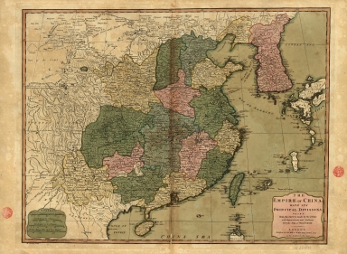
Detail View: Old Maps Collection: The Empire of China with its principal divisions : drawn from the surveys made by the Jesuits, with improvements and additions from the maps of Mons.r D'Anville.
|
Barcode:
|
3687800354473F
|
|
Title:
|
The Empire of China with its principal divisions : drawn from the surveys made by the Jesuits, with improvements and additions from the maps of Mons.r D'Anville.
|
|
Contributor:
|
Anville, Jean Baptiste Bourguignon d', 1697-1782, bibliographic antecedent
|
|
Contributor:
|
Bowen, Maurice, fl. ca. 1780-1794, engraver
|
|
Contributor:
|
Whittle & Laurie, publisher
|
|
Category:
|
General Maps
|
|
Type:
|
Printed
|
|
Language:
|
English
|
|
Language:
|
French
|
|
Language:
|
Spanish
|
|
Language:
|
Portuguese
|
|
Create Year:
|
1794
|
|
Scale:
|
[ca 1:6,300,000].
|
|
Physical Map Dimension (cm):
|
48 x 63 cm, on sheet 55 x 72 cm
|
|
Note:
|
This map is centered on China covering the area from the Chinese Tartary to the Gulf of Tonkin and the northern part of the Philippine Island of Luzon and from the Gobi Desert to Korea and Japan. It also includes the islands of Taiwan and Hainan. Most of the sources for the making of this map were earlier French maps by Jean Baptiste Bourguignon d'Anville. This map is also notorious for belonging to the transitional phase of very illustrated maps to more accurate and simpler maps.
|
|
Note:
|
Original is a copperplate printed map, 50 x 65 cm, on sheet 53 x 72 cm.
|
|
Note:
|
On the left bottom corner of the map: "M. Bonven Sculp."
|
|
Note:
|
Four scale lines inside cartouche on the left bottom corner of the map.
|
|
Note:
|
Relief shown pictorially.
|
|
Note:
|
Different administrative units colored in different colors.
|
|
Note:
|
Map with graticule.
|
|
Note:
|
Prime meridian: Ferro.
|
|
Note:
|
The four borders of the map with latitude and longitude lines in black and white interchangeably.
|
|
Note:
|
Map with yellow border, outlined in bold fillet.
|
|
Note:
|
Macao in China maps.
|
|
Note:
|
Title and scales in English with place names in English, French, Spanish and Portuguese.
|
|
Subject:
|
General Maps
|
|
Geographic Area:
|
China
|
|
Geographic Area:
|
Hainan Sheng (China)
|
|
Geographic Area:
|
Taiwan
|
|
Geographic Area:
|
Korea
|
|
Geographic Area:
|
Japan
|
|
Provenance:
|
Biblioteca Nacional de Portugal
|
|
Provenance:
|
http://id.bnportugal.gov.pt/bib/catbnp/269615
|
|
Provenance Call No.:
|
C.C. 1127 A.
|
|
MUST holding:
|
https://must.primo.exlibrisgroup.com/permalink/853MUST_INST/171sgkf/alma991002999849805076
|