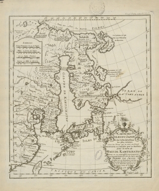
Detail View: Old Maps Collection: Map of the islands of Japan and the closest coasts of China
|
Barcode:
|
3687800354474G
|
|
Title:
|
Map of the islands of Japan and the closest coasts of China
|
|
Original Title:
|
Carte des Isles du Japon et des costes de la Chine les plus voisines : avec les terres qui en sont au Nord découvertes et soumises par les Russiens sous le nom de Pays de Kamtschatka dont on ne connoissoit anciennement que la partie la plus proche du Japon appelle Terre de Jesso dressée sur des relations particulieres et les memoires les plus recens
|
|
Contributor:
|
Bellin, Jacques-Nicolas, 1703-1772, cartographer
|
|
Contributor:
|
Dheulland, Guillaume, d. ca. 1770, engraver
|
|
Category:
|
Atlas
|
|
Type:
|
Printed
|
|
Language:
|
French
|
|
Create Year:
|
1735
|
|
Page No.:
|
254
|
|
Scale:
|
[ca. 1:17,000,000].
|
|
Physical Map Dimension (cm):
|
32 x 28 cm, on sheet 43 x 37 cm
|
|
Note:
|
This map depicts Japan and much of the eastern coast of China, but the focus of the map is the massive Kamchatka Peninsula and the islands northeast of Japan. The long title mentions the discoveries of the Russians, a reference to the recently-completed First Kamchatka Expedition, as well as the mysterious Terre de Jesso. Historically, Eso (Yeco, Jesso, Yedso, Yesso) refers to the island of Hokkaido in northern Japan. It varies on maps from a small island to a near-continent sized mass that stretched from Asia to Alaska. On this particular map Bellin connected not only Hokkaido, but also the Kuril Islands to the Kamchatka Peninsula, a confusion created by the islands of Sakhalin, frequently thought of as a peninsula. Another hypothetical island is also included here, 'Terre de la Compagnie', whose addition to maps stretches back to mid-17th century. In the sixteenth century, the grandson of Vasco de Gama was accused of illegal trading with the Spanish in the East Indies and so fled from Macau to Japan in the later 16th century. He then struck out east, across the Pacific, and supposedly saw lands in the North Pacific. Several voyagers sought out de Gama’s lands, including the Dutchman Maarten Gerritszoon Vries in 1643 who sighted the islands Compagnies Land along with Staten Land. He named the island for the Dutch States General (Staten Land) and for the Dutch East India Company (VOC) (Compagnies, or Company’s Land). In reality, he had re-discovered two of the Kuril Islands. However, other mapmakers latched onto Compagnies Land in particular, enlarging and merging it with Yesso. In this map Bellin includes both the Staten Land (I des Etats) and Compagnies Land (Terre de la Compagnie), separated from Kamchatka/Yesso by the Strait of Uries. The First Kamchatka Expedition was Russia’s first scientific exploratory voyage when Peter I ordered the expedition to verify if there was a strait between Asia and America in 1724. The route shown here is not an exact representation of the ships’ voyage, but this is because the French were not privy to extensive information about the voyage. The Russians were keeping the information clandestine, as much as possible, until they completed a Second Kamchatka Expedition. This is an early representation of the expedition’s findings and an intriguing configuration of the North Pacific, which was of increasing interest to Europe in the mid-18th century. Bellin has included many notes, most are ethnographic annotations that discuss indigenous peoples’ relation to the Russians and whether or not they are tributaries of the Russians. A note in the long Kamchatka peninsula reads, “Les Kurilski qu on croit Colonies du Japon connus sous le nom de Terre de Jeso.” which means “The Kurils are believed to be colonies of Japan known by the name Terre de Jeso.” Political subdivisions are marked with dotted lines, while towns and cities are indicated with building symbols.
|
|
Note:
|
Original is a copperplate printed map, 38 x 32 cm.
|
|
Note:
|
Title inside phytomorphic cartouche on the right bottom corner of the map.
|
|
Note:
|
Underneath the cartouche: "Dheulland sculp."
|
|
Note:
|
Four scale lines in black and white interchangeably.
|
|
Note:
|
Relief shown pictorially.
|
|
Note:
|
Map with graticule.
|
|
Note:
|
The four borders of the map with latitude and longitude lines.
|
|
Note:
|
Tropic of Cancer and Polar Circle in double fillet.
|
|
Note:
|
Map outlined in double fillet.
|
|
Note:
|
Macao in Asia maps.
|
|
Reference:
|
Mapping Japan : The Jason C. Hubbard Collection, Part One, p. 167
|
|
Reference:
|
Wroth, L.C. The Early Cartography of the Pacific, In The Papers of the Bibliographical Society of America 38, no. 2 (1944): 87-268
|
|
Reference:
|
Suarez, T. Early Mapping of the Pacific
|
|
Reference:
|
Brooke-Hitching, E. The Phantom Atlas: The Greatest Myths, Lies and Blunders on Maps
|
|
Subject:
|
Atlas
|
|
Geographic Area:
|
Japan
|
|
Geographic Area:
|
Korea
|
|
Geographic Area:
|
China
|
|
Geographic Area:
|
Taiwan
|
|
Relation Note:
|
T. 2. 4.º P. 254 et in 12. T.6. P. 1.ere
|
|
Pub Title:
|
Histoire et description générale du Japon
|
|
Pub Author:
|
Charlevoix, Pierre-François-Xavier de, 1682-1761
|
|
Pub Year:
|
1736
|
|
Pub location:
|
A Paris
|
|
Provenance:
|
Archives Nationales de France
|
|
Provenance:
|
https://www.siv.archives-nationales.culture.gouv.fr/siv/IR/FRAN_IR_050187
|
|
Provenance Call No.:
|
NN/169/15
|
|
MUST holding:
|
https://must.primo.exlibrisgroup.com/permalink/853MUST_INST/171sgkf/alma991002999248905076
|