Detail View: Old Maps Collection: Chine, Province de Kiangsi.
|
Barcode:
|
3687800354476I
|
|
Title:
|
Chine, Province de Kiangsi.
|
|
Category:
|
Description and Travel
|
|
Type:
|
Manuscript
|
|
Language:
|
French
|
|
Language:
|
Latin
|
|
Create Year:
|
[173-]
|
|
Scale:
|
Scale not given.
|
|
Physical Map Dimension (cm):
|
46 x 30 cm, on sheet 49 x 34 cm
|
|
Note:
|
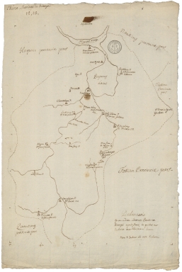
This is a very simple sketch of the Jiangxi Province outlined by a dotted line. Around it, are given the names of the Provinces that surround it. Inside the province one can only see the river courses and the catholic churches, marked with a cross as stated on the note on the right bottom corner of the map. Each church states the Congregation that it belongs to, denoting a clear religious purpose of the map.
|
|
Note:
|
Original is a manuscript map.
|
|
Note:
|
There is a half longitude line on the left bottom of the map.
|
|
Note:
|
The upper border of the map is labelled with North in Latin, Septentrio (Septentriones).
|
|
Note:
|
Title in French with notes in Latin.
|
|
Subject:
|
Description and Travel
|
|
Geographic Area:
|
Jiangxi Sheng (China)
|
|
Provenance:
|
Archives Nationales de France
|
|
Provenance Call No.:
|
MAP/6JJ/74/A/15
|
|
MUST holding:
|
https://must.primo.exlibrisgroup.com/permalink/853MUST_INST/171sgkf/alma991002999248705076
|