Detail View: Old Maps Collection: Carte de l'extremité de Xensi : faite par order de l'Emp.eur.
|
Barcode:
|
3687800354479L
|
|
Title:
|
Carte de l'extremité de Xensi : faite par order de l'Emp.eur.
|
|
Type:
|
Manuscript
|
|
Language:
|
French
|
|
Create Year:
|
[173-]
|
|
Scale:
|
Scale not given.
|
|
Physical Map Dimension (cm):
|
37 x 41 cm, on sheet 46 x 49 cm
|
|
Note:
|
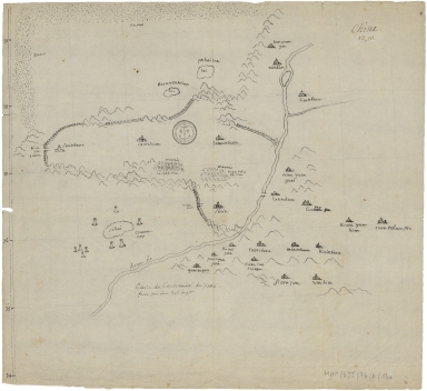
This is a manuscript map depicting the northern part of modern day Qinghai Province. From 1640 to 1724, a big part of the area that is now Qinghai was under Khoshut Mongol control, but in 1724 it was conquered by the armies of the Qing Dynasty. Xining (Sinin), the capital of modern Qinghai province, began to function as an administrative center and, due to its importance, takes the center position on the map. On the map can be seen parts of the Great Wall as well as of the Yellow River (Hoan Ho) and Qinghai Lake (Sihai), the largest lake in China. On the upper part of the map the Gobi Dessert is marked by dots and the major cities of the region are also point out.
|
|
Note:
|
Original is a manuscript map.
|
|
Note:
|
Relief shown pictorially.
|
|
Note:
|
The left border of the map with latitude line.
|
|
Subject:
|
China maps
|
|
Geographic Area:
|
Qinghai Sheng (China)
|
|
Provenance:
|
Archives Nationales de France
|
|
Provenance Call No.:
|
MAP/6JJ/74/A/13a
|
|
MUST holding:
|
https://must.primo.exlibrisgroup.com/permalink/853MUST_INST/171sgkf/alma991002999248605076
|