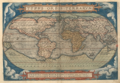
Detail View: Old Maps Collection: Image of the countries of the world.
|
Barcode:
|
3687800354451B
|
|
Title:
|
Image of the countries of the world.
|
|
Original Title:
|
Typvs orbis terrarvm
|
|
Other Title:
|
Typus orbis terrarum
|
|
Contributor:
|
Ortelius, Abraham, 1527-1598, author
|
|
Contributor:
|
Hogenberg, Frans, ca. 1539-1590, engraver
|
|
Category:
|
General Maps
|
|
Type:
|
Printed
|
|
Language:
|
Latin
|
|
Create Year:
|
[1571]
|
|
Page No.:
|
1
|
|
Scale:
|
[1:80,000,000].
|
|
Physical Map Dimension (cm):
|
37 x 50 cm, on sheet 42 x 56 cm
|
|
Note:
|
The Atlas 'Theatrum Orbis Terrarum' of 1571 was the first time the elements of the modern atlas were brought to publication by Abraham Ortelius. This first edition of the Atlas or the 20th May 1570 edition is composed of 53 map sheets with descriptive text on verso. The maps were collected from renowned and up-to-date cartographers and geographers with the intention to bound as many as small maps as he could on a book to be easily handled instead the inconvenient large maps. All the maps present on the Atlas were engraved according to uniform format and specifically for it. This world map is a reproduction of the large map from Mercator from the previous year with new co-ordinates of places in America provided by himself. From Mercator's map were omitted the legends, textual panels, and decorative features and now clouds surround the map with a quotation from Cicero on a cartouche on the bottom. The original plate was signed 'Franciscus Hogenbergus sculpsit' and was used for the first 16 editions of the 'Theatrum' in different languages.
|
|
Note:
|
Original map is from the atlas 'Theatrum Orbis Terrarum' from Abraham Ortelius copperplate printed in 1571 and hand colored, 34 x 49 cm. The atlas has 53 maps.
|
|
Note:
|
On the bottom part of the map: "Franciscus Hogenbergus sculpsit"
|
|
Note:
|
The map has latitude lines on both sides and longitude on the bottom. The four map borders are labelled with North, South, East and West in Latin Septentrio (Septentriones), Meridies, Oriens and Occidens respectively.
|
|
Note:
|
The maps depicts one vessel and three sea monsters.
|
|
Note:
|
Relief is shown pictorially.
|
|
Reference:
|
Shirley, R.W. Mapping of the world, 122
|
|
Reference:
|
Phillips, P.L. A list of geographical atlases in the Library of Congress, with bibliographical notes, vol. 1, 374, vol. 3, 3389
|
|
Reference:
|
Koeman, C. Atlantes Neerlandici, Ort 2
|
|
Reference:
|
Nordenskiöld, A.E. Facsimile-Atlas to the Early History of Cartography With Reproductions of the Most Important Maps Printed in the XV and XVI Centuries, p. 90, pl. XLVI
|
|
Reference:
|
Schilder, G. Monumenta Cartographica Neerlandica, Map 12
|
|
Reference:
|
Cartographica Neerlandica http://www.orteliusmaps.com/book/ort1.html
|
|
Subject:
|
Atlas
|
|
Geographic Area:
|
World
|
|
Relation Note:
|
[Pl. 1]
|
|
Pub Title:
|
[Theatrum Orbis Terrarum]
|
|
Pub Author:
|
Ortelius, Abraham, 1527-1598
|
|
Pub Year:
|
1571
|
|
Pub location:
|
Antuerpiae
|
|
Provenance:
|
Biblioteca Nacional de Portugal
|
|
Provenance:
|
http://id.bnportugal.gov.pt/bib/catbnp/279930
|
|
Provenance Call No.:
|
C.A. 117 V.
|
|
MUST holding:
|
https://must.primo.exlibrisgroup.com/permalink/853MUST_INST/171sgkf/alma991002999249705076
|