Detail View: Old Maps Collection: A New Depiction of Asia.
|
Barcode:
|
3687800354448H
|
|
Title:
|
A New Depiction of Asia.
|
|
Original Title:
|
Asiae nova descriptio
|
|
Contributor:
|
Ortelius, Abraham, 1527-1598, author
|
|
Contributor:
|
Cónegos Regrantes de Santo Agostinho. Mosteiro de São Vicente de Fora (Lisboa), former owner
|
|
Category:
|
General Maps
|
|
Type:
|
Printed
|
|
Language:
|
Latin
|
|
Create Year:
|
[1584]
|
|
Page No.:
|
3
|
|
Scale:
|
[1: 28,000,000].
|
|
Physical Map Dimension (cm):
|
37 x 48 cm, on sheet 43 x 55 cm
|
|
Note:
|
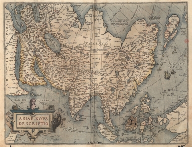
The Atlas 'Theatrum Orbis Terrarum' of 1584 was the first time the elements of the modern atlas were brought to publication by Abraham Ortelius. This first edition of the Atlas or the 20th May 1570 edition is composed of 53 map sheets with descriptive text on verso. The maps were collected from renowned and up-to-date cartographers and geographers with the intention to bound as many as small maps as he could on a book to be easily handled instead the inconvenient large maps. All the maps present on the Atlas were engraved according to uniform format and specifically for it. This map represents the Asian continent at a time when Europeans were expanding their power in the far east. Showing all of Asia, India, Indonesia, the Philippines. The Indian subcontinent and Malaysian peninsula are easily recognizable and Ceylon and Sumatra are correctly placed. However, the Philippines are distorted and Japan is too far north and incorrectly orientated, with the embryonic outline of the three main islands and Taiwan appearing as a tail of islands to the south of the archipelago. Papua New Guinea is enlarged and Australia still appears as 'Terrae Incognitae'. Scattered through the map are notes on many places but they are still mainly fanciful.
|
|
Note:
|
Original map is from the atlas 'Theatrum Orbis Terrarum' from Abraham Ortelius copperplate printed in 1584 and hand colored, 38 x 49 cm. The atlas has 53 maps. It belonged to the Livraria do Mosteiro de S. Vicente de Fora.
|
|
Note:
|
There are two sail ships on the Pacific Ocean.
|
|
Note:
|
Title inside strap work cartouche on the bottom eft side of the map, headed by a bust.
|
|
Note:
|
Equator line as longitude line in black and white interchangeably. The four map borders are labelled with North, South, East and West in Latin Septentrio (Septentriones), Meridies, Oriens and Occidens respectively.
|
|
Note:
|
Relief shown pictorially.
|
|
Note:
|
Different countries outlined in different colors.
|
|
Note:
|
Map with graticule.
|
|
Note:
|
Map with ornamented border, outlined in double fillet.
|
|
Reference:
|
Tibbets, G.R. Arabia in Early Maps, map 41, p. 52-53
|
|
Reference:
|
Suarez, T. Early Mapping of Southeast Asia, p. 164-170
|
|
Reference:
|
Koeman, C. Atlantes Neerlandici, Ort 7
|
|
Reference:
|
Cartographica Neerlandica, http://www.orteliusmaps.com/book/ort7.html
|
|
Subject:
|
Atlas
|
|
Geographic Area:
|
Asia
|
|
Geographic Area:
|
Africa
|
|
Geographic Area:
|
India
|
|
Geographic Area:
|
Malaysia
|
|
Geographic Area:
|
China
|
|
Geographic Area:
|
Borneo
|
|
Geographic Area:
|
Philippines
|
|
Geographic Area:
|
Indonesia
|
|
Geographic Area:
|
Vietnam
|
|
Geographic Area:
|
Japan
|
|
Geographic Area:
|
Papua New Guinea
|
|
Relation Note:
|
[Pl. 3]
|
|
Pub Title:
|
Theatrum Orbis Terrarum
|
|
Pub Author:
|
Ortelius, Abraham, 1527-1598
|
|
Pub Year:
|
1584
|
|
Pub location:
|
Antuerpiae
|
|
Provenance:
|
Biblioteca Nacional de Portugal
|
|
Provenance:
|
http://id.bnportugal.gov.pt/bib/catbnp/279946
|
|
Provenance Call No.:
|
C.A. 148 V.
|
|
MUST holding:
|
https://must.primo.exlibrisgroup.com/permalink/853MUST_INST/171sgkf/alma991002999249805076
|