Detail View: Old Maps Collection: A map of the East Indies and surrounding islands
|
Barcode:
|
3687800301587D
|
|
Title:
|
A map of the East Indies and surrounding islands
|
|
Original Title:
|
Indiae orientalis, insvlarvmqve adiacientivm typvs
|
|
Other Title:
|
Indiae orientalis, insularumque adjacientium typus
|
|
Contributor:
|
Ortelius, Abraham, 1527-1598, author
|
|
Contributor:
|
Norton, John, 15---1612, printer
|
|
Category:
|
General Maps
|
|
Type:
|
Printed
|
|
Language:
|
Latin
|
|
Language:
|
Portuguese
|
|
Language:
|
Spanish
|
|
Create Year:
|
[1606]
|
|
Format:
|
JPEG 8352 × 5542, 60.3MB
|
|
Page No.:
|
113
|
|
Scale:
|
[1:22,000,000].
|
|
Physical Map Dimension (cm):
|
35 x 49 cm, on sheet 60 x 85 cm
|
|
Note:
|
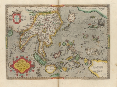
Abraham Ortelius published in 1570 in Antwerp the reputed first modern atlas 'Theatrum Orbis Terrarum'. It contains originally 53 maps later updated continuously by Ortelius in 'Additamenti' until his death in 1598. By 1612 the atlas had already 31 editions in many languages. This map of Southeast Asia was included in every edition of the atlas since 1570 until 1612. In the map are depicted India, China, the Bay of Bengal, the Himalaya Mountains, the Canton River, Thailand, Taiwan, Cambodia, Sri Lanka, Malaysia, Japan, Indonesia and New Guinea including a small section of the west coast of California on the right top corner. It is the first printed map to identify Taiwan, still named 'Fermosa'. Sumatra and Java are heavily oversize, the Philippines are incomplete and without the Northern island of Luzon and Korea is still missing. The map is focused on the islands that were the obsession of Europe, the so-called 'Spice Islands' that were rich in resources the Europeans wanted to trade. The note on the banderole right above New Guinea states exactly this, mentioning that the famous Maluku islands are next to Gilolo, exporting all over the world a great abundance of fragrant spices. On New Guinea -here named 'Nova Guinea'- the notes seem to clarify that it is called Piccinaculusland by Andreas Corsalis and whether this is an island or part of the South Land it is uncertain. This is an early map depicting the world and East Asia before the Portuguese established the permanent settlement in Macao.
|
|
Note:
|
Original is a copperplate printed map water colored by hand, 37 x 47 cm, on sheet 42 x 54 cm. This map is from the 1606 English edition of the 'Theatrum Orbis Terrarum' by Abraham Ortelius.
|
|
Note:
|
Coat of arms of Portugal on Persia on the left upper corner of the map. On the sea there are two European vessels, one of them being attacked by two giant sea monsters. There are also two mermaids beautifying themselves taken from the splendid map of America of Diego Gutiérrez of 1562.
|
|
Note:
|
Title inside strap work cartouche on the left bottom corner of the map.
|
|
Note:
|
Relief is shown pictorially.
|
|
Note:
|
The four borders of the map labelled with North, South, East and West in Latin Septentrio (Septentriones), Meridies, Occidens and Oriens respectively.
|
|
Note:
|
Latitude and longitude lines framing the map in black and white interchangeably.
|
|
Note:
|
Land masses outlined in different colors. Islands colored green, yellow and brown.
|
|
Note:
|
Map with roped border.
|
|
Note:
|
Macao in Asia Maps.
|
|
Note:
|
Title, privilege, legends, land and water masses in Latin with place names in Latin, Spanish and Portuguese.
|
|
Reference:
|
Suarez, T. Early Mapping of Southeast Asia, p. [164]-169
|
|
Reference:
|
Karrow, R.W. Mapmakers of the Sixteenth Century and Their Maps, 1/68
|
|
Reference:
|
Durand. F. Maps of Malaya and Borneo, 11
|
|
Reference:
|
Nordenskiöld, A.E. Periplus, fig. 86, p. 164-170
|
|
Reference:
|
Cartographica Neerlandica http://www.orteliusmaps.com/book/ort166.html
|
|
Subject:
|
Theater
|
|
Geographic Area:
|
Southeast Asia
|
|
Geographic Area:
|
China
|
|
Geographic Area:
|
India
|
|
Geographic Area:
|
Malaysia
|
|
Geographic Area:
|
Sumatra (Indonesia)
|
|
Geographic Area:
|
Vietnam
|
|
Geographic Area:
|
Cambodia
|
|
Geographic Area:
|
Myanmar
|
|
Geographic Area:
|
Thailand
|
|
Geographic Area:
|
Borneo
|
|
Geographic Area:
|
Java (Indonesia)
|
|
Geographic Area:
|
Philippines
|
|
Geographic Area:
|
Timor Island
|
|
Geographic Area:
|
Papua New Guinea
|
|
Geographic Area:
|
Pacific Ocean
|
|
Relation Note:
|
[Pl. 113]
|
|
Pub Title:
|
Theatrum Orbis Terrarum Abrahami Orteli[i] Antuerp. : The theatre of the whole world
|
|
Pub Author:
|
Ortelius, Abraham, 1527-1598
|
|
Pub Year:
|
1606
|
|
Pub location:
|
London
|
|
Provenance:
|
Harvard College Library
|
|
Provenance:
|
http://id.lib.harvard.edu/alma/990088585650203941/catalog
|
|
Provenance Call No.:
|
GEN (MO 1.1606 pf*)
|
|
MUST holding:
|
https://must.primo.exlibrisgroup.com/permalink/853MUST_INST/reglfj/alma991000042899705076
|