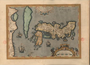
Detail View: Old Maps Collection: A representation of the island of Japan by Luis Teixeira
|
Barcode:
|
3687800354408D
|
|
Title:
|
A representation of the island of Japan by Luis Teixeira
|
|
Original Title:
|
Iaponiae Insvlae descriptio
|
|
Other Title:
|
Japoniae Insulae descriptio
|
|
Contributor:
|
Teixeira, Luís, 1564-1604, cartographer
|
|
Category:
|
General Maps
|
|
Type:
|
Printed
|
|
Language:
|
Latin
|
|
Language:
|
Portuguese
|
|
Language:
|
Spanish
|
|
Create Year:
|
1612
|
|
Page No.:
|
386
|
|
Scale:
|
[1:4,500,000].
|
|
Physical Map Dimension (cm):
|
36 x 48 cm, on sheet 48 x 62 cm
|
|
Note:
|
Abraham Ortelius published in 1570 in Antwerp the reputed first modern atlas 'Theatrum Orbis Terrarum'. It contains originally 53 maps later updated continuously by Ortelius in 'Additamenti' until his death in 1598. By 1612 the atlas had already 31 editions in many languages. This map is a milestone in the cartography of Japan, and surprisingly accurate as far as the Japanese islands are concerned. The Portuguese cartographer Luís Teixeira was one of the outstanding personalities in a family of cartographers that followed this profession through five to six generations. He was active not only in Lisbon, utilizing information brought back from the Portuguese and foreign voyages, but that he also made original surveys in the Azores and Brazil. His sources for this map remain mostly unknown, although, some authors state the Portuguese Jesuit Inácio Moreira (ca. 1538-). This map was without a doubt the most accurate one at the time, retained influence until more than 50 years later and promulgate the so called Teixeira-type. Japan is divided in three main islands, 'Japonia' (Honshu), Bungo (Kyushu) and Tonsa (Shikoku) . It is however missing the island of Hokkaido, named in the first maps as 'Yezo' or 'Ezo'. Korea is shown as an island, even named 'Corea Insula', however, there is deliberate hazing at the top of Korea as if to demonstrate the ambiguity of the information while other authors chose to separate it completely. This map was so influential that part of it was reproduced on a stamp of 60 ¥en issued by the Japanese government in 1985.
|
|
Note:
|
Original is a copper plate printed map water colored by hand. This map is from the 1612 Spanish edition of the 'Theatrum Orbis Terrarum' by Abraham Ortelius.
|
|
Note:
|
There are three European sail ships on sea.
|
|
Note:
|
Title inside strapwork cartouche in the upper middle part of the map.
|
|
Note:
|
Scale line in miles inside strapwork cartouche with a face at the top.
|
|
Note:
|
The bottom and right borders of the map labelled with South and East in Latin Meridies and Oriens respectively.
|
|
Note:
|
The four borders of the map with latitude and longitude lines in white and red interchangeably.
|
|
Note:
|
Land masses in different colors.
|
|
Note:
|
Relief is shown pictorially.
|
|
Note:
|
Map inside yellow roped border.
|
|
Note:
|
Title, scale, privilege and land and water masses in Latin with place names in Portuguese and Spanish.
|
|
Reference:
|
Cortesão, A. Portugaliae Monumenta Cartographica, vol. 3, p. 65-70
|
|
Reference:
|
Cortesão, A. Cartografia e cartógrafos portugueses dos séculos XV e XVI, vol. 2, p. 266
|
|
Reference:
|
Hubbard, J. Japoniae insulae : the mapping of Japan, p. 49-54 ; n.º 6, p. 139-142
|
|
Reference:
|
Walter, L. Japan: A Cartographic Vision, n.º 19, p. 188
|
|
Reference:
|
Koeman's Atlantes Neerlandic, vol. 3A, p. 222
|
|
Reference:
|
Cartographica Neerlandica http://www.orteliusmaps.com/book/ort165.html
|
|
Subject:
|
Atlas
|
|
Geographic Area:
|
Japan
|
|
Geographic Area:
|
Korea
|
|
Geographic Area:
|
China
|
|
Relation Note:
|
[386]
|
|
Pub Title:
|
Theatro D'el Orbe de la Tierra
|
|
Pub Author:
|
Ortelius, Abraham, 1527-1598
|
|
Pub Year:
|
1612
|
|
Pub location:
|
Anveres
|
|
Provenance:
|
Biblioteca Nacional de Portugal
|
|
Provenance:
|
http://id.bnportugal.gov.pt/bib/catbnp/280111
|
|
Provenance Call No.:
|
C.A. 32 A.
|
|
MUST holding:
|
https://must.primo.exlibrisgroup.com/permalink/853MUST_INST/171sgkf/alma991002994249805076
|