Detail View: Old Maps Collection: A new representation of China, once called the region of the Chinese, by Ludovicus Georgius.
|
Barcode:
|
3687800354405A
|
|
Title:
|
A new representation of China, once called the region of the Chinese, by Ludovicus Georgius.
|
|
Original Title:
|
Chinae : olim Sinarum regionis, nova descriptio
|
|
Other Title:
|
Barbuda China
|
|
Contributor:
|
Barbuda, Luís Jorge de, fl. 1575-1584, cartographer
|
|
Contributor:
|
Plantijnsche Drukkerij, printer
|
|
Category:
|
General Maps
|
|
Type:
|
Printed
|
|
Language:
|
Latin
|
|
Language:
|
Portuguese
|
|
Language:
|
Spanish
|
|
Create Year:
|
1584
|
|
Page No.:
|
383
|
|
Scale:
|
[1:2,800,000].
|
|
Physical Map Dimension (cm):
|
37 x 47 cm, on sheet 46 x 62 cm
|
|
Note:
|
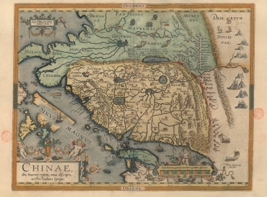
Abraham Ortelius published in 1570 in Antwerp the reputed first modern atlas 'Theatrum Orbis Terrarum'. It contains originally 53 maps later updated continuously by Ortelius in 'Additamenti' until his death in 1598. By 1612 the atlas had already 31 editions in many languages. This map of China by the Portuguese cartographer Luís Jorge de Barbuda -Latin name Ludovicus Georgius- was a manuscript map which reached Ortelius via Arias Montanus. It first appeared in the 1584 Latin edition of the atlas. The text on verso includes four transcriptions of Chinese characters, brought back to Europe by the Jesuit Bernadino de Escalante in 1577. This exact item however is from the 1612 Spanish edition of the atlas printed in Antwerp. This China map is the earliest known, so far, made on one single map by Europeans. The landscape of China was drawn like a rectangle; the coastline from northern areas to Zhejiang province was wrongly drawn as a north-south straight line, while the coastline from Fujian province to Guangdong province is relatively accurate. The most prominent feature of this map is the names of two capitals and 13 provinces of Ming Dynasty thoroughly marked for the first time, and the outdated place names no longer figure. For the first time on a printed map it is depicted the Great Wall of China with a legend correctly describing its defensive purpose against the Tartars and Mongols but making it shorter in length. At the center there is a depiction of the Lake Baikal with a little kid on top of a trunk that is explained by the a legend stating that in 1557 there was a flood that created said lake and inundated seven communities resulting in a gigantic number of dead people except for this one boy saved by climbing onto the trunk. Macau -here named 'Macoa'- is written on land in the east coast of the Pearl River. The description of the river system in China was full of grasslands, showing that Europeans had little knowledge of Chinese inland regions at that time. Despite all of this, when the map appeared, it was by far the most accurate one of China and became the standard map of the interior of China for over 60 years. Japan is shown on a curious curved projection reminiscent of Portuguese charts of the period with Honshu dissected along the line of Lake Biwa. On the map it is written 'Las Philippinas' -used for the first time on a printed map applied to the archipelago instead of just one island- above 'Sinus Magnus', which first appeared on the map during the publication of the 1587 French edition.
|
|
Note:
|
Original is a copper plate printed map water colored by hand. This map is from the 1612 Spanish edition of the 'Theatrum Orbis Terrarum' by Abraham Ortelius.
|
|
Note:
|
There are depicted four wind wagons on the right bottom and top center of the map, one of the earliest depiction of this device, that in Europe originated in the Low Countries, but which had been invented much earlier in China. On the sea there is only one sea monster and two European vessel. On the rightmost part of the map are depicted the Tartar yurt tents. Fauna is also present on the map with representations of elephants in India and deer in Tartary.
|
|
Note:
|
Title inside an ornamented cartouche on the left bottom corner of the map with two cherubs at the top and an owl on the right side. Privilege and date in the left upper corner in a cartouche with a bird on each side.
|
|
Note:
|
Scale line inside an ornamented cartouche with a cherub holding a compass at the top.
|
|
Note:
|
The four borders of the map labelled with North, South, East and West in Latin Septemtrio [sic] (Septentriones), Meridies, Oriens and Occidens respectively.
|
|
Note:
|
Latitude lines at the top and bottom.
|
|
Note:
|
Oriented with West at the top.
|
|
Note:
|
Land masses outlined in different colors. Islands colored green and yellow.
|
|
Note:
|
Relief shown pictorially.
|
|
Note:
|
Map inside flowery border.
|
|
Note:
|
Macao in China Maps.
|
|
Note:
|
Title, scale, privilege, legends, land and water masses in Latin with place names in Latin, Spanish and Portuguese.
|
|
Reference:
|
Cortesão, A. Portugaliae Monumenta Cartographica, vol. 2, p. 123-125
|
|
Reference:
|
Cortesão, A. Cartografia e cartógrafos portugueses dos séculos XV e XVI, vol. 2, p. 276-285
|
|
Reference:
|
Suarez, T. Early Mapping of Southeast Asia, p. 170
|
|
Reference:
|
Walter, L. Japan: A Cartographic Vision 11F, p. 186
|
|
Reference:
|
Nordenskiöld, A.E. Periplus, fig. 77, p. 164-170
|
|
Reference:
|
Tooley, R.V. Maps and Mapmakers, p. 106, pl. 78
|
|
Reference:
|
Tooley's Dic. of mapmakers, A-D [vol. 1], p. 83
|
|
Reference:
|
Picatoste y Rodríguez, F. Apuntes para una biblioteca científica española del siglo XVI, p. 23
|
|
Reference:
|
Nebenzahl, K. Mapping the Silk Road and Beyond 4.6
|
|
Reference:
|
Cartographica Neerlandica http://www.orteliusmaps.com/book/ort164.html
|
|
Subject:
|
Atlas
|
|
Geographic Area:
|
China
|
|
Geographic Area:
|
Philippines
|
|
Geographic Area:
|
Paracel Islands
|
|
Geographic Area:
|
Vietnam
|
|
Geographic Area:
|
Cambodia
|
|
Geographic Area:
|
Myanmar
|
|
Geographic Area:
|
Taiwan
|
|
Geographic Area:
|
Japan
|
|
Geographic Area:
|
Hainan Sheng (China)
|
|
Geographic Area:
|
Borneo
|
|
Geographic Area:
|
Thailand
|
|
Geographic Area:
|
India
|
|
Geographic Area:
|
Malaysia
|
|
Relation Note:
|
[383]
|
|
Pub Title:
|
Theatro D'el Orbe de la Tierra
|
|
Pub Author:
|
Ortelius, Abraham, 1527-1598
|
|
Pub Year:
|
1612
|
|
Pub location:
|
Anveres
|
|
Provenance:
|
Biblioteca Nacional de Portugal
|
|
Provenance:
|
http://id.bnportugal.gov.pt/bib/catbnp/280111
|
|
Provenance Call No.:
|
C.A. 32 A.
|
|
MUST holding:
|
https://must.primo.exlibrisgroup.com/permalink/853MUST_INST/171sgkf/alma991002992949205076
|