Detail View: Old Maps Collection: Macau and vicinity
|
Barcode:
|
36878003712439
|
|
Title:
|
Macau and vicinity
|
|
Contributor:
|
United States. Army Map Service, author
|
|
Category:
|
Harbors
|
|
Type:
|
Printed
|
|
Language:
|
English
|
|
Language:
|
Portuguese
|
|
Create Year:
|
[1954]
|
|
Page No.:
|
49
|
|
Scale:
|
ca. 1:15,000 ; Transverse Mercator proj.
|
|
Physical Map Dimension (cm):
|
29 x 26 cm, on sheet 56 x 74 cm
|
|
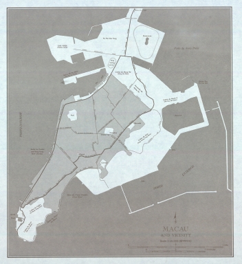
Note:
|
The map is a simple outline of Macao with the main streets and some of the most important places marked. It can be seen some of the land reclamation such as the northern Areia Preta where the 'Racecourse' is marked, and Toi San. The Green Island is already connected to land.
|
|
Note:
|
Original is a printed map, 69 x 52 cm.
|
|
Note:
|
Double scale line in miles and kilometers underneath the title in the right bottom corner of the map.
|
|
Note:
|
Simple arrow indicating north above the title.
|
|
Note:
|
Map outlined in double fillet.
|
|
Note:
|
City plans of Macao.
|
|
Note:
|
Title in English but place names on the map mostly in Portuguese and some in English and Cantonese transliteration.
|
|
Subject:
|
Harbors
|
|
Geographic Area:
|
Macao (China)
|
|
Relation Note:
|
[NF 49-8v.]
|
|
Pub Title:
|
China 1:250,000
|
|
Pub Author:
|
United States. Army Map Service.
|
|
Pub Year:
|
1954
|
|
Pub location:
|
Washington
|
|
Provenance:
|
University of California, Los Angeles Library
|
|
Provenance:
|
https://catalog.library.ucla.edu/vwebv/holdingsInfo?bibId=3334279
|
|
Provenance Call No.:
|
G7810.s250 U54
|
|
MUST holding:
|
https://must.primo.exlibrisgroup.com/permalink/853MUST_INST/171sgkf/alma991002965949805076
|