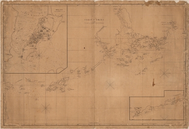
Detail View: Old Maps Collection: Coast of China
|
Barcode:
|
3687800371237C
|
|
Title:
|
Coast of China
|
|
Other Title:
|
Macao.
|
|
Other Title:
|
[Huilling-San Island and Southwest coast of Canton].
|
|
Contributor:
|
Arrowsmith, Aaron, 1750-1823, publisher
|
|
Category:
|
General Maps
|
|
Type:
|
Printed
|
|
Language:
|
English
|
|
Create Year:
|
1812
|
|
Scale:
|
[ca 1:300,000].
|
|
Physical Map Dimension (cm):
|
65 x 97 cm, on sheet 69 x 101 cm
|
|
Note:
|
This hydrographic chart seems to be extremely rare and it is the second earliest map to properly name Hong Kong. The chart covers the largely incomplete coastline of Guangzhou with notes by the author scattered throughout the map admitting the need for more complete surveys. For this map Arrowsmith compiled the information from Daniel Ross' (1780-1849) 1810 'This chart of the different Passages leading to Macao Roads' - the first map to use the name Hong Kong- and 1807 'This Survey of part of the South Coast of China'. Arrowsmith ignores the more advanced cartography around Macao from the 'Macao Roads' in favor of the outlines of the 'South Coast of China'. This raises the possibility that Arrowsmith was taking his map directly from a single Daniel Ross manuscript map. Because Ross was not allowed into Macao, and could not survey the area, the inset of Macao is based on John Barrow's (1764-1848) 1796 'A plan of the city and harbor of Macao a colony of the Portugueze situated at the southern extremity of the Chinese Empire'. On the large Macao inset the city is represented geometrically, typical of a plan. On land there are marked the forts, churches, pagodas and squares and on sea detailed soundings of the inner harbor. The other inset is of the Hailing Island and the Shuanhshan, Dashu, Ilha Verde, Shizai, Xiaofangji and Dafangji islands.
|
|
Note:
|
Inset 1: Macao. - Scale [ca 1:3,500]. - 36 x 33 cm. -- Inset 2: [Huilling-San Island and Southwest coast of Canton]. - Scale not given. - 16 x 29 cm.
|
|
Note:
|
Original is a copperplate printed map, 66 x 98 cm, on sheet 68 x 100 cm.
|
|
Note:
|
There are three 32-point compass roses on the map, one on inset 1 and half compass rose on inset 2.
|
|
Note:
|
Scale line in feet in inset 1 underneath its title.
|
|
Note:
|
Relief shown by hachures and bathymetric relief by soundings.
|
|
Note:
|
The four borders of the map with latitude and longitude lines.
|
|
Note:
|
Map with graticule.
|
|
Note:
|
Map and insets outlined in simple fillet.
|
|
Note:
|
Macao and its surroundings.
|
|
Geographic Area:
|
China
|
|
Geographic Area:
|
Macao (China)
|
|
Geographic Area:
|
Taipa Island (China)
|
|
Geographic Area:
|
Coloane Island (China)
|
|
Geographic Area:
|
Hong Kong (China)
|
|
Provenance:
|
Biblioteca Nacional de Portugal
|
|
Provenance:
|
http://id.bnportugal.gov.pt/bib/catbnp/556682
|
|
Provenance Call No.:
|
C.C. 573 R.
|
|
MUST holding:
|
https://must.primo.exlibrisgroup.com/permalink/853MUST_INST/171sgkf/alma991002952249705076
|