Detail View: Old Maps Collection: City of Macao (Ao-Men) : Portuguese territory
|
Barcode:
|
36878003542104
|
|
Title:
|
City of Macao (Ao-Men) : Portuguese territory
|
|
Other Title:
|
China, South Coast
|
|
Other Title:
|
[Macao and Hong Kong].
|
|
Contributor:
|
United States. Office of Strategic Services. Research and Analysis Branch, publisher
|
|
Category:
|
Harbors
|
|
Type:
|
Printed
|
|
Language:
|
English
|
|
Language:
|
Portuguese
|
|
Create Year:
|
1945
|
|
Scale:
|
1:7,000.
|
|
Physical Map Dimension (cm):
|
61 x 52 cm, on sheet 64 x 55 cm
|
|
Note:
|
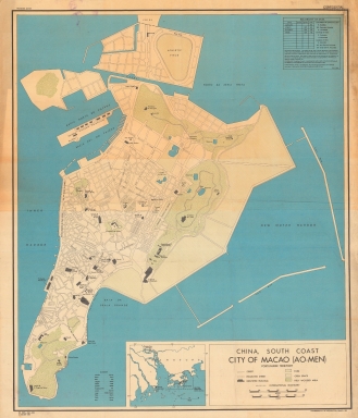
This map was made by the Research Analysis Branch of the Office of Strategic Services of the United States of America on the beginning of the year of the end of World War II. The map collects information of Macao with the already claimed territory, although still blank. There are marked the Inner and Outer Harbor and the most important buildings such as forts, hospitals, churches, cemeteries and others. Some street names are also included. On the bottom part of the map there is a small inset with Macao and Hong Kong marking both the Portuguese and British territories. A legend on the right top corner of the map states the reliability levels of the given information.
|
|
Note:
|
Original is a colored lithograph.
|
|
Note:
|
On the right bottom corner of the map: "Lithographed in the Reproduction Branch, OSS."
|
|
Note:
|
Double scale line in meters and yards in black and white interchangeably. Scale line of the inset in miles.
|
|
Note:
|
Four borders of the inset with latitude and longitude lines.
|
|
Note:
|
Relief shown pictorially.
|
|
Note:
|
Map outlined in simple fillet.
|
|
Note:
|
City plans of Macao.
|
|
Note:
|
Title and legend in English with place names in both English and Portuguese. Street names in Portuguese.
|
|
Subject:
|
Harbors
|
|
Geographic Area:
|
Macao (China)
|
|
Provenance:
|
中央研究院 - Academia Sinica
|
|
Provenance Call No.:
|
map_moi2_1moi00156
|
|
MUST holding:
|
https://must.primo.exlibrisgroup.com/permalink/853MUST_INST/171sgkf/alma991002966949805076
|