Detail View: Old Maps Collection: [Planisfero]
|
Barcode:
|
3687800354239F
|
|
Title:
|
[Planisfero]
|
|
Other Title:
|
Carta del 1554, comprende anco America
|
|
Contributor:
|
Homem, Lopo, fl. 1517-1565, cartographer
|
|
Category:
|
World Map
|
|
Type:
|
Manuscripts
|
|
Language:
|
Portuguese
|
|
Language:
|
Latin
|
|
Create Year:
|
1554
|
|
Scale:
|
Scale not given.
|
|
Physical Map Dimension (cm):
|
49 x 78 cm, on sheet 55 x 85 cm
|
|
Note:
|
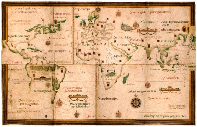
This is the second largest early Portuguese chart extant and the largest in one single piece. It seems to have been created for Cosino I (1519-1574) of the Florence Medicis. The work by Lopo Homem influenced a lot of cartographers including the Homem family especially his son Diogo Homem. This chart represents the coastal limits of the known world in the mid-16th century and it is the first map to show Argentina, designated as 'Terra Argentea'. Both North and South America are not fully drawn yet. As most of Homem's map a lot of focus is given to coastal place names with few or none nomenclature on land.
|
|
Note:
|
Original is a manuscript map in 8 parchment sheets of 60 x 77 cm or smaller, mounted 143 x 224 cm. On the back it has the note "Carta del 1554, comprende anco America".
|
|
Note:
|
There are eight coat of arms on the map, five of them being Portuguese and there is one in each continent with the exception of Europe. It can also be seen a lot of Portuguese, Spanish and Turkish banderoles scattered throughout the map. The Amazon River is represented as a serpent, as it was Homem's trademark and in Africa it can be seen the 'Mons Lunae' or Mountains of the Moon, a mythical mountain range at the source of the Nile River. There are 10 compass roses on the map, all 32-point. Nine have an arrow indicating north and the bigger one has a fleur de lis, they are colored red, blue, green and yellow. The rhumb lines for the principal winds are black, for the half winds green and the quarter winds red.
|
|
Note:
|
Four tables of leagues inside decorative cartouches.
|
|
Note:
|
Relief shown pictorially.
|
|
Note:
|
There are two latitude lines. The one north of the Equator is in the Atlantic Sea, and south of the Equator is west to the African coast. Colored red, blue and gold interchangeably.
|
|
Note:
|
Landmasses outlined in green with bigger islands colored also green. Small islands colored green, red, blue and gold. The Caspian Sea is colored blue.
|
|
Note:
|
Equator line, the Tordesillas meridian and the Zaragoza meridian colored gold and Tropic and Polar Circles in red.
|
|
Note:
|
The four borders of the map labelled with North, South, East and West in Latin Septentrio (Septentriones), Meridies, Oriens and Occidens.
|
|
Note:
|
Map framed in yellow and bown.
|
|
Note:
|
The Equator, Tropics, Polar Circles, Climate zones, Seas and Landmasses in Latin. With legend with the name of the author and place names in Portuguese.
|
|
Reference:
|
Cortesão, A. Portugaliae Monumenta Cartographica, vol. 1, p. 67-68
|
|
Reference:
|
Caraci, G. World map by Lopo Homem, 1554, Tabulae Geographicae Vetustiores in Italia Adservatae, vol. 1, p. 1-3
|
|
Reference:
|
Wieder, F.C. Discovery and Early Cartography [...], The iconography of Manhattan island, vol. 2, p. 22, 39, 134
|
|
Reference:
|
Abendanon, E.C. Voyages géologiques et géographiques à travers la Célèbes Centrale, vol. 3, p. 1408
|
|
Reference:
|
Crinò, S. Portolani manoscritti e carte da navigare compilati per la marina medicea
|
|
Subject:
|
Nautical Chart
|
|
Geographic Area:
|
World
|
|
Provenance:
|
Museo Galileo
|
|
Provenance:
|
https://opac.museogalileo.it/imss/resource?uri=1004969&v=l&dcnr=0
|
|
Provenance Call No.:
|
SD A 037
|
|
MUST holding:
|
https://must.primo.exlibrisgroup.com/permalink/853MUST_INST/171sgkf/alma991002970348805076
|