Detail View: Old Maps Collection: [Luconia]
|
Barcode:
|
3687800354244B
|
|
Title:
|
[Luconia]
|
|
Other Title:
|
[Buccaneer atlas]
|
|
Other Title:
|
[Hack's descript of ye East Indies]
|
|
Contributor:
|
Hacke, William, fl. 16--, cartographer
|
|
Contributor:
|
Sharpe, Bartholomew, fl. 1679-1682, author
|
|
Category:
|
Nautical Chart
|
|
Type:
|
Manuscripts
|
|
Language:
|
English
|
|
Language:
|
Portuguese
|
|
Language:
|
Dutch
|
|
Create Year:
|
[ca. 1690]
|
|
Page No.:
|
65
|
|
Scale:
|
Scale not given.
|
|
Physical Map Dimension (cm):
|
59 x 47 cm, on sheet 66 x 56 cm
|
|
Note:
|
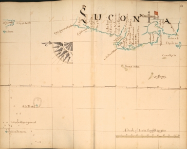
William Hacke and Bartholomew Sharpe were Buccaneers, also known as the Brethren of the Coast, a kind of privateers or free sailors. These privateers were nominally licensed by the authorities -first the French, later the English and Dutch- to prey on the Spanish, until their depredations became so severe they were suppressed. With both their experience they created this manuscript atlas with charts of the sea coasts of the East Indies. Each drawing bears a brief description with soundings, distances and facts regarding anchorages and navigation of rivers which might be of value in pirating activities. On this particular chart it is depicted the Luzon -here named Luconia- the largest and most populous island in the Philippines. The city of Manila -Manilhas on the map- is marked with a castle with a flag with the Cross of Burgundy that served as a naval ensign of the Spanish Empire up to 1701.
|
|
Note:
|
Original is a manuscript watercolor chart, 47 x 38 cm, from the Atlas 'A description of the sea coasts [...] in the East Indies'. This atlas is known as the 'Buccaneer atlas' because it results from the experience of Hacke in association with Captain Bartholomew Sharpe, the notorious Buccaneer on various expeditions to the South Sea.
|
|
Note:
|
Title from provenance library.
|
|
Note:
|
There is a quarter of a 32-point compass rose with a half fleur-de-lis indicating north. Manila marked with the representation of a castle.
|
|
Note:
|
Scale line in English leagues.
|
|
Note:
|
Latitude line in the middle of the chart in black and white interchangeably.
|
|
Note:
|
Bathymetric relief shown by soundings.
|
|
Note:
|
Map with graticule.
|
|
Note:
|
Landmasses outlined in blue.
|
|
Note:
|
Place names in English, Portuguese and Dutch.
|
|
Reference:
|
Phillips, 3162
|
|
Subject:
|
Nautical Chart
|
|
Subject:
|
Coasts
|
|
Geographic Area:
|
Philippines
|
|
Geographic Area:
|
Luzon (Philippines)
|
|
Relation Note:
|
[65]
|
|
Pub Title:
|
Description of the sea coasts [...] in the East Indies
|
|
Pub Author:
|
Hacke, William, fl. 16--
|
|
Pub Year:
|
[ca. 1690]
|
|
Pub location:
|
[S.l.]
|
|
Provenance:
|
Library of Congress
|
|
Provenance:
|
https://lccn.loc.gov/2002626774
|
|
Provenance Call No.:
|
G2201.P5 .H3 1690 Vault.
|
|
MUST holding:
|
https://must.primo.exlibrisgroup.com/permalink/853MUST_INST/171sgkf/alma991002973749505076
|