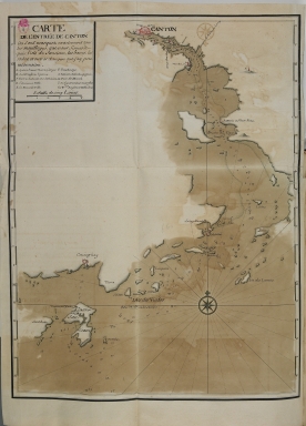
Detail View: Old Maps Collection: Carte de l'entrée de Canton : ou sont marquez exactement tous les mouillages, que nous fismes depuis l'isle de Sanciam, les bancs, les roches, et autres dangers que j'ay peu reconnoitre
|
Barcode:
|
3687800354369J
|
|
Title:
|
Carte de l'entrée de Canton : ou sont marquez exactement tous les mouillages, que nous fismes depuis l'isle de Sanciam, les bancs, les roches, et autres dangers que j'ay peu reconnoitre
|
|
Contributor:
|
Froger, François, 1676-1715, cartographer
|
|
Category:
|
General Maps
|
|
Type:
|
Manuscripts
|
|
Language:
|
French
|
|
Create Year:
|
[ca. 1698]
|
|
Scale:
|
Scale indeterminable.
|
|
Physical Map Dimension (cm):
|
37 x 28 cm, on sheet 45 x 35 cm
|
|
Note:
|
This is a nautical chart as all the information provided is either on the coast line or on the water with the inland mostly black. The map depicts a somewhat incomplete coast line of the areas around Macao and the Pearl River. The coast line of the east bank of the Pearl River Estuary is much more detailed than the one on the west, that is quite lacking. Some soundings are provided mostly only the route that Froger's ship followed passing by Shangchuan Island (Sanciam) Coloane (Matchong) up the Pearl River through Humen (Bouche du Tigre) until Guangzhou (Canton) with a few Pagodas marked along the way. There is the Lotus Pagoda or Wenchang Pagoda (Tour du Lion), the Pazhou Pagoda and the Red Stone Hill Pagoda or Chigang Pagoda. The most detailed information is military with the location of a lot of forts and batteries. Macao show the city separated from Wangxia by the city wall and also has forts marked as well and the Inner Harbor.
|
|
Note:
|
Original is a colored manuscript map from the manuscript 'Relation du Premier voyage des François a la Chine' by François Froger.
|
|
Note:
|
The stylized geometry of buildings are colored pink. There is an 32-point compass rose colored red, blue and gold, with a fleur-de-lis indicating north. The rhumb lines for the principal winds are in bold, the half-winds in simple lines and the quarter-winds in dash-dotted lines.
|
|
Note:
|
Scale line inside title cartouche underneath the legend.
|
|
Note:
|
Relief shown pictorially and bathymetric relief by soundings.
|
|
Note:
|
Latitude line in black and white interchangeably on both sides of the map.
|
|
Note:
|
Land masses outlined in green.
|
|
Note:
|
Map and title cartouche outlined in double fillet.
|
|
Note:
|
Macao and its surroundings.
|
|
Pub Title:
|
Relation du Premier voyage des François a la Chine
|
|
Pub Author:
|
Froger, François, 1676-1715
|
|
Pub Year:
|
1698-1700
|
|
Pub location:
|
[S.l.]
|
|
Provenance:
|
Biblioteca da Ajuda
|
|
Provenance Call No.:
|
52-XIV-23
|
|
MUST holding:
|
https://must.primo.exlibrisgroup.com/permalink/853MUST_INST/171sgkf/alma991002992949405076
|