Detail View: Old Maps Collection: Macau (Macao)
|
Barcode:
|
36878003712428
|
|
Title:
|
Macau (Macao)
|
|
Other Title:
|
China City Graphic 1:10,000
|
|
Other Title:
|
Boundaries.
|
|
Contributor:
|
United States. Army Topographic Command, publisher
|
|
Category:
|
Harbors
|
|
Type:
|
Printed
|
|
Language:
|
English
|
|
Language:
|
Portuguese
|
|
Create Year:
|
[ca. 195-]
|
|
Scale:
|
1:10,000 ; Transverse Mercator proj.
|
|
Physical Map Dimension (cm):
|
31 x 33 cm, on sheet 49 x 38 cm
|
|
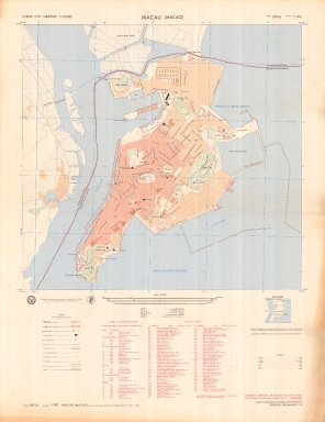
Note:
|
This is a rather detailed map of Macao with some street names on the map and an additional 84 names on an index bellow the map. On the map in black are marked important buildings and outlined in red are another 33 important features. The coloring of the city also gives information on the population density. The map also and the inset outlines the boundaries of China and Portugal.
|
|
Note:
|
Inset 1: Boundaries. - Scale not given. - 3 x 3 cm.
|
|
Note:
|
On the left upper corner of the map: "China City Graphic 1:10,000".
|
|
Note:
|
Coat of arms of the Department of Defense of the United States and of the Army Topographic Command on the bottom left part of the map.
|
|
Note:
|
Triple scale line in meters, yards and statute miles in black and white interchangeably on the bottom part of the map.
|
|
Note:
|
Relief shown pictorially and by spot heights.
|
|
Note:
|
Map with graticule.
|
|
Note:
|
City plans of Macao.
|
|
Note:
|
Title in Portuguese and English with street names and place names in Portuguese. The legend and notes in English and the glossary with the Portuguese translation of public ways to English.
|
|
Subject:
|
Harbors
|
|
Geographic Area:
|
Macao (China)
|
|
Provenance:
|
中央研究院 - Academia Sinica
|
|
Provenance Call No.:
|
B-3081-0962-36
|
|
MUST holding:
|
https://must.primo.exlibrisgroup.com/permalink/853MUST_INST/171sgkf/alma991002966049805076
|