Detail View: Old Maps Collection: [Carte nautiche : Asia]
|
Barcode:
|
36878003542407
|
|
Title:
|
[Carte nautiche : Asia]
|
|
Other Title:
|
[Sea charts]
|
|
Contributor:
|
Velho, Bartolomeu, ca. 15---1568, cartographer
|
|
Category:
|
Nautical Chart
|
|
Type:
|
Manuscripts
|
|
Language:
|
Portuguese
|
|
Create Year:
|
1561
|
|
Page No.:
|
4
|
|
Scale:
|
Scale not given.
|
|
Physical Map Dimension (cm):
|
41 x 27 cm, on sheet 51 x 35 cm
|
|
Note:
|
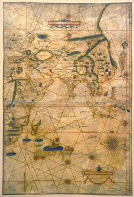
Bartolomeu Velho was a Portuguese cosmographer and cartographer who entered the service of France towards the end of his life. He held a unique place in Portuguese 16th century cartography in the dual capacity of cosmographer and cartographer and no other Portuguese cartographic works of said century are known that achieve the same range and precision. This chart is part of a total of four charts depicting the whole world that do not join perfectly together on the lateral margins, but rather overlap with common strips, which makes some regions appear twice. This chart of the Indian Ocean is notorious for it geographical detail of many of the regions and the up-to-date information. Contrary to the generality of the Portuguese charts of its time, which have a purely nautical character, with interior of the Continents filled with ornamental motives, this depicts rivers, mountains, people, regions, etc. with up-to-date character, using details of the period and reducing the classical elements to a minimum. On China it can be seen a lake with the note 'City of Sansin which was flooded, with 7 cities and 153 villages, in the year 1557'. The lake appears further inland with similar legends on the China chart by Luís Jorge de Barbuda (fl. 1575-1584) and on Petrus Plancius (1552-1622) planisphere of 1604. The Great Wall of China is intertwined with the mountains between China and Tartary. Japan is depicted with outline and nomenclature very similar to that of the 'Teixeira type', although with totally different orientation. Yezo is here recorded for the first time.
|
|
Note:
|
Original is a manuscript chart in parchment, 113 x 83 cm, from a total of four charts depicting the whole world.
|
|
Note:
|
Title from provenance library.
|
|
Note:
|
There are three vessels in gold, each one on a blue circle on the south coast of Africa. A banderole describes the 1497 voyage of Vasco da Gama (ca. 146--1524) with a representation of a soldier with a Cross of the Order of Christ on its armor, a sword on the right hand and a Portuguese flag on the left. There are nine coats of arms of Portugal scattered on many countries in Africa and Asia. There are eight 32-point compass roses on the map. The smaller ones have an arrow indicating north and the bigger one a fleur de lis. The first are colored red, blue and green and the latter in red, blue, green and gold. The rhumb lines for the principal winds are black, for the half winds green and the quarter winds red. It can be seen eight red stars of the zodiac with the nomenclature in blue.
|
|
Note:
|
Author, place and year on the right bottom corner of the chart in an ornamented cartouche.
|
|
Note:
|
Two tables of leagues on the chart inside a red border. One at the top of the chart decorated with blue scrollwork motives and the other above the author cartouche.
|
|
Note:
|
Latitude line on the right side of the map in blue and white interchangeably.
|
|
Note:
|
Equator, Tropics and two Polar Circles lines colored red.
|
|
Note:
|
Relief shown pictorially.
|
|
Note:
|
Landmasses and big islands outlined in green with smaller islands colored red, blue and green. Rivers colored blue.
|
|
Note:
|
Map outlined in multiple fillet border.
|
|
Note:
|
Place names written both in black and red.
|
|
Reference:
|
Cortesão, A. Portugaliae Monumenta Cartographica, vol. 2, p. 95-101
|
|
Reference:
|
Loureiro, R.M. News from China in sixteenth century Europe: the Portuguese connection, History Of Mathematical Sciences: Portugal And East Asia Ii - Scientific Practices And The Portuguese Expansion In Asia (1498-1759), p. [99]-112
|
|
Reference:
|
Simonova-Gudzenko, E. Visual Representation of Japan in early Portuguese maps: the case of the [Moreira]-Teixeira map [Ortelius 1545], History Of Mathematical Sciences: Portugal And East Asia V - Visual And Textual Representations In Exchanges Between Europe And East Asia 16th - 18th Centuries, p. 119-136
|
|
Reference:
|
Mihoko, O. Elusive Islands of Silver: Japan in the early European Geographic Imagination, Cartographic Japan: A History in Maps, p. 20-23
|
|
Reference:
|
Almagià, R. Sul mappamondo di Bartolomeo Velho, Rivista Geografica Italiana, annata XIX, fasc. 3, p. 222-223
|
|
Reference:
|
Marinelli, G. Recente ritrovamento di carte nautiche e planisferi, Rivista Geografica Italiana, vol. 4, p. 454-456
|
|
Reference:
|
Faria, A.P. Bartholomeu Velho: descoberta d'um planispherio de 1561
Marques, A.P. Japan in early Portuguese maps
|
|
Subject:
|
East Indies
|
|
Geographic Area:
|
East Indies
|
|
Geographic Area:
|
Africa
|
|
Geographic Area:
|
Asia
|
|
Geographic Area:
|
Madagascar
|
|
Geographic Area:
|
India
|
|
Geographic Area:
|
China
|
|
Geographic Area:
|
Philippines
|
|
Geographic Area:
|
Borneo
|
|
Geographic Area:
|
Persia
|
|
Geographic Area:
|
Arabian Peninsula
|
|
Geographic Area:
|
Sumatra (Indonesia)
|
|
Geographic Area:
|
Vietnam
|
|
Geographic Area:
|
Paracel Islands
|
|
Geographic Area:
|
Java (Indonesia)
|
|
Geographic Area:
|
Japan
|
|
Relation Note:
|
[4]
|
|
Pub Title:
|
[Sea charts]
|
|
Pub Author:
|
Velho, Bartolomeu, ca. 15---1568
|
|
Pub Year:
|
1561
|
|
Pub location:
|
Lisbon
|
|
Provenance:
|
Museo Galileo
|
|
Provenance:
|
https://opac.museogalileo.it/imss/resource?uri=16455&v=l&dcnr=2
|
|
Provenance Call No.:
|
DIA sez 07/ id. 20149
|
|
MUST holding:
|
https://must.primo.exlibrisgroup.com/permalink/853MUST_INST/171sgkf/alma991002973349705076
|