Detail View: Old Maps Collection: Indiae orientalis nova descriptio
|
Barcode:
|
4687820500222
|
|
Title:
|
Indiae orientalis nova descriptio
|
|
Original Title:
|
Indiae orientalis nova descriptio
|
|
Contributor:
|
Jansson, Jan, 1588-1664
|
|
Category:
|
Sea Charts
|
|
Type:
|
Printed
|
|
Language:
|
Latin
|
|
Create Year:
|
1633
|
|
Format:
|
JPEG, 8250 × 5911, 62.1MB
|
|
Scale:
|
[ca. 1:11,400,000]
|
|
Note:
|
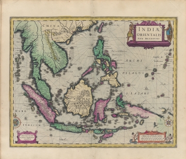
A classic Dutch map covering all of South-east Asia including the Philippines and part of the newly discovered Landt vande Papuos [i.e. Papua New Guinea] represented as a peninsula of the southern continent. It is historically significant as the first map to reflect the Dutch contact with New Guinea and Australia. The map includes many decorative features such as the title cartouche featuring local warriors, two lesser cartouches containing the author's name and a mileage scale, two compass roses, sea monsters and a ship.
|
|
Note:
|
Macao and the surrounding islands were depicted in this map.
|
|
Note:
|
Macao in East Indies Maps
|
|
Geographic Area:
|
Southeast Asia
|
|
Geographic Area:
|
India
|
|
Geographic Area:
|
Indonesia
|
|
Pub Title:
|
[Gerardi Mercatori.] Atlas, ou Represéntation du monde universel et des parties d’icelui, faicte en tables et descriptions.
|
|
Pub Author:
|
Mercator, Gerhard, 1512-1594
|
|
Pub Year:
|
1633
|
|
Pub location:
|
Amsterdam
|
|
Provenance:
|
Harvard Map Collection - Harvard College Library
|