Detail View: Old Maps Collection: England
|
Barcode:
|
3687800239899T
|
|
Title:
|
England
|
|
Contributor:
|
Lancaster, Elizabeth Lilian, 1852-1939, cartographer
|
|
Contributor:
|
Brooks, Vincent, 1815?-1885, lithographer
|
|
Contributor:
|
Day & Son, lithographer
|
|
Contributor:
|
Hodder and Stoughton, publisher
|
|
Category:
|
Caricature
|
|
Type:
|
Printed
|
|
Language:
|
English
|
|
Create Year:
|
[ca. 1868]
|
|
Page No.:
|
1
|
|
Scale:
|
Scale not given.
|
|
Physical Map Dimension (cm):
|
28 x 24 cm, on sheet 58 x 40 cm
|
|
Note:
|
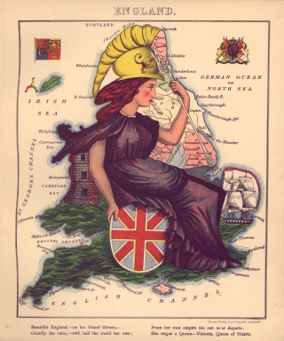
This map is from the book 'Geographical fun : being humorous outlines of various countries, with an introduction and descriptive lines' in which the maps are drawn by Elizabeth Lilian Lancaster. She was only 15 years old at the time and made them to amuse her ill brother. However, the author of the text, under the name Aleph, was William Harvey, a London doctor and journalist. Lancaster’s maps both taught geography and incorporated important political events and figures. The collection of maps together with the text are a one sided cartoonish view held by England and Englishmen of the political situation of the countries represented. In fact, this map of England is the first of the book and the only one that doesn't have a negative connotation or offensive intent. Just as what happens with the depiction also the verses are the only flattering ones, a true exaltation to the English empire scattered all over the world.
|
|
Note:
|
Original is a colored caricature printed map from the book 'Geographical fun', 24 x 28 cm.
|
|
Note:
|
England is depicted as a figure of Minerva impersonated by Queen Victoria seated on a shield with the flag of the United Kingdom and leaned on a castle tower. On her left hand there is a double edged spear and at her feet a ship representing the English Armada. On the upper part of the map on the left side there is a flag with the coat of arms of the Prince of Wales and on the right the English coat of arms.
|
|
Note:
|
Land masses and islands outlined with bathymetric isolines.
|
|
Note:
|
Map outlined in triple fillet.
|
|
Subject:
|
Caricatures
|
|
Geographic Area:
|
England
|
|
Relation Note:
|
1
|
|
Pub Title:
|
Geographical fun : being humourous outlines of various countries, with an introduction and descriptive lines
|
|
Pub Author:
|
Harvey, William, 1796-1866
|
|
Pub Year:
|
[ca. 1868]
|
|
Pub location:
|
London
|
|
Provenance:
|
Library of Congress
|
|
Provenance:
|
https://lccn.loc.gov/84675540
|
|
Provenance Call No.:
|
G1796.A6 H3 1868 Vault.
|
|
MUST holding:
|
https://lccn.loc.gov/84675540
|