Detail View: Old Maps Collection: The Eastern part of East Indies stretching from Ceylon to Japan and New Holland
|
Barcode:
|
3687800354436E
|
|
Title:
|
The Eastern part of East Indies stretching from Ceylon to Japan and New Holland
|
|
Original Title:
|
't Ooster deel van Oost Indien streckende van Ceylon tot Japan en Hollandia Nova
|
|
Other Title:
|
Ooster deel van Oost Indien streckende van Ceylon tot Iapan en Hollandia Nova
|
|
Contributor:
|
Doncker, Hendrick, 1626-1699, cartographer
|
|
Category:
|
General Maps
|
|
Type:
|
Printed
|
|
Language:
|
Dutch
|
|
Language:
|
Latin
|
|
Language:
|
Portuguese
|
|
Language:
|
Spanish
|
|
Create Year:
|
[1665]
|
|
Page No.:
|
29
|
|
Scale:
|
Scale not given.
|
|
Physical Map Dimension (cm):
|
55 x 43 cm, on sheet 60 x 49 cm
|
|
Note:
|
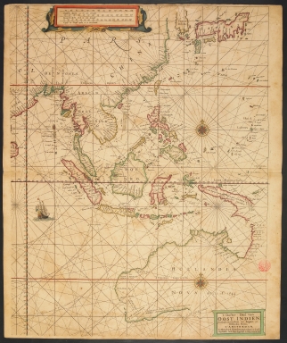
Hendrick Doncker was an Amsterdam publisher of sea charts, atlases and books, cartographer and protractor maker. While improving outdated maps, he also improves his own cartographer qualities and so in 1659, 17 maps of his hand appear in the 19-card 'De zee-atlas or water-waereld'. This particular map os the East Indies is rather detailed with Australia and Papua New Guinea, even though only partially depicted. Made in a nautical chart manner, the focus is mainly given to inshore areas with a lot of toponyms given on coastlines and the interior mainly blank. Korea is half depicted but marked as an island (insula) rather than a peninsula. However, Japan is already drawn in the Teixeira-type but is missing the Hokkaido island, at the time commonly named Yezo or Yeso. Australia appears under the toponym 'Hollandia Nova' (New Holland) and with the date of its discovery. The author is ambiguous and almost connects it with Papua New Guinea, although not completely. Both places are still very scarce in place names. The sources of the map are obviously Portuguese as the toponyms found are mainly in that language with very few in Spanish.
|
|
Note:
|
Original is a copperplate printed map, watercolored by hand.
|
|
Note:
|
There is a sail ship with the Netherlands flag depicted on the map. There are two 32-point compass roses on the map with a fleur-de-lis indicating north and a cross on the East point. The rhumb lines for the principal winds are bold, half-winds are dashed lines and the quarter-winds simple lines.
Triple scale line in Dutch, Spanish, English and French miles inside strap work cartouche.
|
|
Note:
|
Latitude line in red and blue interchangeably on the left edge of the map.
|
|
Note:
|
The Equator line is a longitude line in red and black interchangeably.
|
|
Note:
|
Tropic of Capricorn and Caner lines in red.
|
|
Note:
|
Landmasses outlined in yellow, green and magenta with small islands colored in the same colors.
|
|
Note:
|
Title and scale lines in Dutch with Tropic lines and Equator in Latin and place names in Portuguese and Spanish.
|
|
Reference:
|
Phillips, P.L. A list of Geographical Atlases in LC, vol. I, p. 226-227
|
|
Reference:
|
Koeman, La Cartografia dels Paisos Baixos, p.197
|
|
Subject:
|
East Indies
|
|
Geographic Area:
|
East Indies
|
|
Geographic Area:
|
China
|
|
Geographic Area:
|
India
|
|
Geographic Area:
|
Malaysia
|
|
Geographic Area:
|
Indonesia
|
|
Geographic Area:
|
Vietnam
|
|
Geographic Area:
|
Paracel Islands
|
|
Geographic Area:
|
Thailand
|
|
Geographic Area:
|
Borneo
|
|
Geographic Area:
|
Hainan Sheng (China)
|
|
Geographic Area:
|
Taiwan
|
|
Geographic Area:
|
Philippines
|
|
Geographic Area:
|
Korea
|
|
Geographic Area:
|
Japan
|
|
Geographic Area:
|
Papua New Guinea
|
|
Geographic Area:
|
Australia
|
|
Relation Note:
|
[29]
|
|
Pub Title:
|
[De Zee-Atlas of Water-waereld]
|
|
Pub Author:
|
Doncker, Hendrick, 1626-1699
|
|
Pub Year:
|
[1666]
|
|
Pub location:
|
[Amsterdam]
|
|
Provenance:
|
Biblioteca Nacional de Portugal
|
|
Provenance:
|
http://id.bnportugal.gov.pt/bib/catbnp/280149
|
|
Provenance Call No.:
|
C.A. 101 A.
|
|
MUST holding:
|
https://must.primo.exlibrisgroup.com/permalink/853MUST_INST/171sgkf/alma991002997349805076
|