Detail View: Old Maps Collection: Ireland
|
Barcode:
|
3687800239900
|
|
Title:
|
Ireland
|
|
Contributor:
|
Lancaster, Elizabeth Lilian, 1852-1939, cartographer
|
|
Contributor:
|
Brooks, Vincent, 1815?-1885, lithographer
|
|
Contributor:
|
Day & Son, lithographer
|
|
Contributor:
|
Hodder and Stoughton, publisher
|
|
Category:
|
Caricature
|
|
Type:
|
Printed
|
|
Language:
|
English
|
|
Create Year:
|
[ca. 1868]
|
|
Page No.:
|
4
|
|
Scale:
|
Scale not given.
|
|
Physical Map Dimension (cm):
|
29 x 24 cm, on sheet 59 x 50 cm
|
|
Note:
|
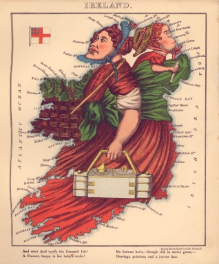
This map is from the book 'Geographical fun : being humorous outlines of various countries, with an introduction and descriptive lines' in which the maps are drawn by Elizabeth Lilian Lancaster. She was only 15 years old at the time and made them to amuse her ill brother. However, the author of the text, under the name Aleph, was William Harvey, a London doctor and journalist. Lancaster’s maps both taught geography and incorporated important political events and figures. The collection of maps together with the text are a one sided cartoonish view held by England and Englishmen of the political situation of the countries represented. This is also easily perceptible as all the countries are caricatures, sometimes very offensive, with the exception of England that is gloriously depicted in the figure of Queen Victoria accompanied by an elegant exaltation. On this particular map the verses are a glossed idea that clarifies the English assumption that Ireland is a nation of servants, happy in their works.
|
|
Note:
|
Original is a colored caricature printed map from the book 'Geographical fun', 24 x 28 cm.
|
|
Note:
|
Ireland is depicted as a muscular farmer with a baby on her back with an herring in hand. A basket full of cabbages dangles from her neck and a working man’s lunch bucket in her left hand. On the left upper corner of the map there is a flag of the United Kingdom of Great Britain and Northern Ireland.
|
|
Note:
|
Land masses and islands outlined with blue bathymetric isolines.
|
|
Note:
|
Map outlined in triple fillet.
|
|
Reference:
|
Lemos, M. ‘Failing Better’com Joyce e Beckett : Um Estudo sobre os Espaços em Murphy e em Finnegans Wake, p. 161
|
|
Subject:
|
Caricatures
|
|
Geographic Area:
|
Ireland
|
|
Relation Note:
|
4
|
|
Pub Title:
|
Geographical fun : being humourous outlines of various countries, with an introduction and descriptive lines
|
|
Pub Author:
|
Harvey, William, 1796-1866
|
|
Pub Year:
|
[ca. 1868]
|
|
Pub location:
|
London
|
|
Provenance:
|
Library of Congress
|
|
Provenance:
|
https://lccn.loc.gov/84675540
|
|
Provenance Call No.:
|
G1796.A6 H3 1868 Vault
|
|
MUST holding:
|
https://must.primo.exlibrisgroup.com/permalink/853MUST_INST/171sgkf/alma991000441719705076
|