Detail View: Old Maps Collection: Scotland
|
Barcode:
|
3687800239897R
|
|
Title:
|
Scotland
|
|
Contributor:
|
Lancaster, Elizabeth Lilian, 1852-1939, cartographer
|
|
Contributor:
|
Brooks, Vincent, 1815?-1885, lithographer
|
|
Contributor:
|
Day & Son, lithographer
|
|
Contributor:
|
Hodder and Stoughton, publisher
|
|
Category:
|
Caricature
|
|
Type:
|
Printed
|
|
Language:
|
English
|
|
Create Year:
|
[ca. 1868]
|
|
Page No.:
|
2
|
|
Scale:
|
Scale not given.
|
|
Physical Map Dimension (cm):
|
28 x 23 cm, on sheet 59 x 40 cm
|
|
Note:
|
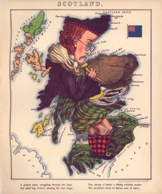
This map is from the book 'Geographical fun : being humorous outlines of various countries, with an introduction and descriptive lines' in which the maps are drawn by Elizabeth Lilian Lancaster. She was only 15 years old at the time and made them to amuse her ill brother. However, the author of the text, under the name Aleph, was William Harvey, a London doctor and journalist. Lancaster’s maps both taught geography and incorporated important political events and figures. The collection of maps together with the text are a one sided cartoonish view held by England and Englishmen of the political situation of the countries represented. This is also easily perceptible as all the countries are caricatures, sometimes very offensive, with the exception of England that is gloriously depicted in the figure of Queen Victoria accompanied by an elegant exaltation. On this particular map once again the verse mocks Scotland for it's self proclaimed past glory that the English don't care about and shun.
|
|
Note:
|
Original is a colored caricature printed map from the book 'Geographical fun', 24 x 28 cm.
|
|
Note:
|
Pictorial map showing Scotland in the form of a kilted Highlander carrying a broken wind bag. On the right top corner is the flag of the United Kingdom of Great Britain and Northern Ireland.
|
|
Note:
|
Land masses and islands outlined with blue bathymetric isolines.
|
|
Note:
|
Map outlined in triple fillet.
|
|
Reference:
|
Sazykina, A.A. Face of place : developing a method of embodying personal impressions about place in a image of the human face building on theories of humanistic geography, antropomorphism, and physiognomy, pp. 25-26
|
|
Subject:
|
Caricatures
|
|
Geographic Area:
|
Scotland
|
|
Relation Note:
|
2
|
|
Pub Title:
|
Geographical fun : being humourous outlines of various countries, with an introduction and descriptive lines
|
|
Pub Author:
|
Harvey, William, 1796-1866
|
|
Pub Year:
|
[ca. 1868]
|
|
Pub location:
|
London
|
|
Provenance:
|
Library of Congress
|
|
Provenance:
|
https://lccn.loc.gov/84675540
|
|
Provenance Call No.:
|
G1796.A6 H3 1868 Vault
|
|
MUST holding:
|
https://must.primo.exlibrisgroup.com/permalink/853MUST_INST/171sgkf/alma991000441619705076
|