Detail View: Old Maps Collection: Sketch of the Typa and Macao
|
Barcode:
|
36878003542148
|
|
Title:
|
Sketch of the Typa and Macao
|
|
Contributor:
|
Harrison, William, 17---ca. 18--
|
|
Contributor:
|
Nicol, George, ca. 1740-1828, publisher
|
|
Contributor:
|
Cadell, Thomas, 1742-1802, publisher
|
|
Category:
|
General Maps
|
|
Type:
|
Printed
|
|
Language:
|
English
|
|
Language:
|
Portuguese
|
|
Create Year:
|
[1785]
|
|
Page No.:
|
81
|
|
Scale:
|
Scale [ca. 1:92,000].
|
|
Physical Map Dimension (cm):
|
26 x 20 cm, on sheet 28 x 20 cm
|
|
Note:
|
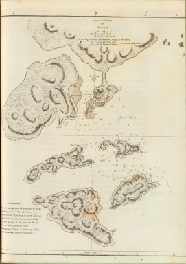
This map was drawn according to information collected by the fleet of Captain James Cook, a famous British navigator, explorer and cartographer, during his third Pacific cruise in 1780. It was published on the work 'Voyage to the Pacific Ocean, undertaken by the Command of His Majesty, For Making Discoveries In the Northern Hemisphere' and details the hydrological data, waterways, backshores, water depth, latitudinal and longitudinal co-ordinates of Macao and its five neighboring islands -Lapa, Macarira, Montanha, Taipa and Coloane; all unnamed here. Originally Taipa was the cross water way constituted between the Taipa Island, Coloane and small Hengqin Island -but the Portuguese mistook Taipa as the name of the Island, which remained until today. On the map this water way is correctly marked ad 'Typa'. The waterway located at the southwest of the Macao Peninsula to Guangzhou was marked as 'Macao Road'. On Macao it can be seen a small plan of the town. The Taipa Island is still divided in Small Taipa and Big Taipa. A small reference note on the left bottom corner of the map gives navigational aid between the points marked on the map. Below the title are marked changes of tides in Macao courses following the lunar phases. When there is a full moon water rises six feet at 5k:15m in Taipa and at 5:50 in the Macao Harbor.
|
|
Note:
|
Original is a printed map, 32 x 27 cm.
|
|
Note:
|
On the bottom right corner of the map: "W.H."
|
|
Note:
|
A 4-point compass rose on the background of the map with a fleur de lis at the top indicating north.
|
|
Note:
|
Bottom border of the map with longitude line.
|
|
Note:
|
Relief shown by hachures and bathymetric relief by soundings.
|
|
Note:
|
Map outlined in double fillet.
|
|
Note:
|
Macao and its surroundings.
|
|
Note:
|
City plans of Macao.
|
|
Note:
|
Map in English with the Green Island name in Portuguese.
|
|
Reference:
|
David, A. The charts and coastal views of Captain Cook's voyages, 3, 187A
|
|
Geographic Area:
|
Macao (China)
|
|
Geographic Area:
|
Taipa Island (China)
|
|
Geographic Area:
|
Coloane Island (China)
|
|
Relation Note:
|
Vol. 3, 81
|
|
Pub Title:
|
Voyage to the Pacific Ocean, undertaken by the Command of His Majesty, For Making Discoveries In the Northern Hemisphere
|
|
Pub Author:
|
Cook, James, 1728-1779
|
|
Pub Year:
|
1785
|
|
Pub location:
|
London
|
|
Provenance:
|
David Rumsey Map Collection
|
|
Provenance:
|
https://www.davidrumsey.com/luna/servlet/s/1b2m2y
|
|
Provenance Call No.:
|
3405024
|
|
MUST holding:
|
https://must.primo.exlibrisgroup.com/permalink/853MUST_INST/171sgkf/alma991002967749705076
|