Detail View: Old Maps Collection: Exacta & accurata delineatio cum orarum maritimarum tum etiam locorum terrestrium quae in regionibus China, Cauchinchina, Camboja sive Champa, Syao, Malac[c]a, Arracan & Pegu, una cum omnium vicinarum insularum descriptione ut sunt Samatra, Java utraq[ue], Timora, Moluccae, Philippinae, Luconia & de Lequeos dictae, nec non insulae Japan & Corea, reliquaeq[ue] omnes adjacentes, ubi etiam adnotavimus scopulos, brevia, omniaq[ue] vadosa loca, & siquae alia a quibus periculum navigantibus. Que madmodum singula hoc aevo à Lusitanis navium gubernatoribus comperta, indigetata, & in tabulas relata fuere. E quorum recentibus ac emendatis tabulis perquàm studiosè haec describi exprimiq[ue] curavimus, in eorum hominum co[m]modum quibus ista usui volupatiq[ue] esse consueuerunnt = The trew description of all the coasts of China, Cauchinchina Camboya, Sӱao, malacca, Arracan, and Pegu, together with all the islands there abowts, both great and smale, with the cliffes, breaches, sands, droughts and shallowes, all perfectly drawne and examined with the most expert cardes of the Portingales pilots.
|
Barcode:
|
3687800354409E
|
|
Title:
|
Exacta & accurata delineatio cum orarum maritimarum tum etiam locorum terrestrium quae in regionibus China, Cauchinchina, Camboja sive Champa, Syao, Malac[c]a, Arracan & Pegu, una cum omnium vicinarum insularum descriptione ut sunt Samatra, Java utraq[ue], Timora, Moluccae, Philippinae, Luconia & de Lequeos dictae, nec non insulae Japan & Corea, reliquaeq[ue] omnes adjacentes, ubi etiam adnotavimus scopulos, brevia, omniaq[ue] vadosa loca, & siquae alia a quibus periculum navigantibus. Que madmodum singula hoc aevo à Lusitanis navium gubernatoribus comperta, indigetata, & in tabulas relata fuere. E quorum recentibus ac emendatis tabulis perquàm studiosè haec describi exprimiq[ue] curavimus, in eorum hominum co[m]modum quibus ista usui volupatiq[ue] esse consueuerunnt = The trew description of all the coasts of China, Cauchinchina Camboya, Sӱao, malacca, Arracan, and Pegu, together with all the islands there abowts, both great and smale, with the cliffes, breaches, sands, droughts and shallowes, all perfectly drawne and examined with the most expert cardes of the Portingales pilots.
|
|
Other Title:
|
Exacta et accurata delineatio cim orarum maritimarum tuum etiam locorum terrestrium quae in regionibus China, Cauchinchina, Camboja sive Champa, Syao, Malacca, Arracan et Pegu, una cum omnium vicinarum insularum descriptione ut sunt Samatra, Java utraq[ue], Timora, Moluccae, Philippinae, Luconia et de Lequeos dictae, nec non insulae Japan et Corea, reliquaeq[ue] omnes adjacentes, ubi etiam adnotavimus scopulos, brevia, omniaq[ue] vadosa loca, et siquae alia à quibus periculum navigantibus. Que madmodum singula hoc aevo à Lusitanis navium gubernatoribus comperta, indigetata, et in tabulas relata fuere. E quorum recentibus ac emendatis tabulis perquàm studiosè haec describi exprimiq[ue] curavimus, in eorum hominum co[m]modum quibus ista usui volupatiq[ue] esse consueuerunnt
|
|
Other Title:
|
True description of all the coasts of China, Cauchinchina Cambodia, Sian, Malacca, Arracan, and Pegu, together with all the islands thereabouts, both great and small, with the cliffs, beaches, sands, droughts and shallows, all perfectly drawn and examined with the most expert charts of the Portuguese pilots
|
|
Other Title:
|
Trew description of all the coasts of China, Cauchinchina Camboya, Syao, Malacca, Arracan, and Pegu, together with all the islands there abowts, both great and smale, with the cliffes, breaches, sands, droughts and shallowes, all perfectly drawne and examined with the most expert cardes of the Portingales pilots
|
|
Contributor:
|
Linschoten, Jan Huygen van, 1563-1611, cartographer
|
|
Contributor:
|
Beckit, Robert, engraver
|
|
Contributor:
|
Wolfe, John, ca. 1547-1601, printer
|
|
Category:
|
General Maps
|
|
Type:
|
Printed
|
|
Language:
|
Latin
|
|
Language:
|
English
|
|
Language:
|
Portuguese
|
|
Language:
|
Spanish
|
|
Create Year:
|
1598
|
|
Page No.:
|
32
|
|
Scale:
|
Scale [ca 1:13,000,000].
|
|
Physical Map Dimension (cm):
|
38 x 50 cm, on sheet 46 x 57 cm
|
|
Note:
|
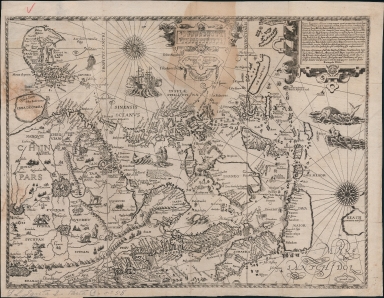
This map produced by John Wolfe in 1598 for a pirated English translation of Linschoten's 'Itinerario' under the title 'John Huighen van Linschoten his Discours of Voyages unto ye Easte and Weste Indies'. The work is basically an instruction sailing manual to the East Indies that help terminate Portuguese trade hegemony in Asia. It was among the most important sources of information on Southeast Asia during the 16th century. Linschoten acquired most of the information about Southeast Asia during his employment as secretary to the Portuguese archbishop in Goa from 1583 to 1589. This map is clearly based on Portuguese portolan charts, mostly from Fernão Vaz Dourado, Bartolomeu Lasso and Jorge Luís de Barbuda, however, there is also an influence from Plancius, that curiously enough also had Portuguese sources on the base of his maps. On the map are depicted China, Japan, Korea, the Philippines, Strait of Malacca, Borneo, Java, Timor and part of Papua New Guinea, there is also the mythical land of Marco Polo 'Beach provincia aurifera' where Australia would eventually be discovered. Korea is still depicted as an island as was common at the time. Japan is still represented in the 'Dourado type', opposed to the later 'Teixeira type', and China is obviously based on the map 'Chinae, olim Sinarum regionis, nova descriptio' by Barbuda, who depicts the interior with a network of rivers emanating from several large lakes.
|
|
Note:
|
Original is a copper plate printed map for the 'John Huighen van Linschoten his Discours of Voyages unto ye Easte and Weste Indies' by Jan Huygen Linschoten, 37 x 51 cm, on sheet 41 x 53 cm.
|
|
Note:
|
Inside the strap work cartouche of the scale line, on the bottom: "Printed at London by John Wolfe 1598". Underneath the same cartouche: "Graven by Robert Beckit"
|
|
Note:
|
Title on ornamented cartouche on the right upper corner of the map.
|
|
Note:
|
There are three vessels on the map and five sea monsters. In China are representations of many animals: elephant, camel, giraffe and rhinoceros. There are two 32-point compass roses on the map with a fleur-de-lis indicating north and a dot on the East point.
|
|
Note:
|
Map oriented with East at the top with latitude lines on both the top and bottom.
|
|
Note:
|
Scale lines in 'Miliaria Germanica' and 'Hispanicae leucae' inside strap work cartouche in the middle upper part of the map.
|
|
Note:
|
Tropic of Cancer and Equator in double line.
|
|
Note:
|
Relief shown pictorially.
|
|
Note:
|
Map inside roped border.
|
|
Note:
|
Macao in Asia maps.
|
|
Note:
|
Parallel title in Latin and English. Legends, Tropic of Cancer and the Equator, water masses and some land masses in Latin with place names in Portuguese and Spanish.
|
|
Reference:
|
Suarez, T. Early Mapping of Southeast Asia, p. 178-179
|
|
Reference:
|
Garcia, J.M. Tesouros da Cartografia portuguesa em Portugal. In: Tesouros da cartografia portuguesa, 81
|
|
Reference:
|
Schilder, G. Australia Unveiled, Map 18
|
|
Reference:
|
Walter, L. Japan Cat., no. 12
|
|
Reference:
|
Quirino, C. Philippine cartography, p. 27, 77
|
|
Subject:
|
Atlas
|
|
Geographic Area:
|
Southeast Asia
|
|
Geographic Area:
|
East Asia
|
|
Geographic Area:
|
China
|
|
Geographic Area:
|
Japan
|
|
Geographic Area:
|
Korea
|
|
Geographic Area:
|
Vietnam
|
|
Geographic Area:
|
Paracel Islands
|
|
Geographic Area:
|
Hainan Sheng (China)
|
|
Geographic Area:
|
Sumatra (Indonesia)
|
|
Geographic Area:
|
Java (Indonesia)
|
|
Geographic Area:
|
Borneo
|
|
Geographic Area:
|
Philippines
|
|
Geographic Area:
|
Papua New Guinea
|
|
Geographic Area:
|
Cambodia
|
|
Geographic Area:
|
Malaysia
|
|
Geographic Area:
|
Taiwan
|
|
Relation Note:
|
32 and 33
|
|
Pub Title:
|
John Huighen van Linschoten his Discours of Voyages unto ye Easte and Weste Indies
|
|
Pub Author:
|
Linschoten, Jan Huygen van, 1563-1611
|
|
Pub Year:
|
1598
|
|
Pub location:
|
London
|
|
Provenance:
|
Biblioteca Pública de Évora
|
|
Provenance:
|
http://evoraopacgib.bibliopolis.info/OPAC/b.aspx?CLI=EVORA&X1=Evora_GiB_Catalogo&id=76889
|
|
Provenance Call No.:
|
BPE-RES Gav 2 Pasta C nº 55.
|
|
MUST holding:
|
https://must.primo.exlibrisgroup.com/permalink/853MUST_INST/171sgkf/alma991002993949705076
|