Detail View: Old Maps Collection: Exacta & accurata delineatio cùm orarum maritimarum tùm etiam locorum terrestrium quae in regionibus China, Cauchinchina, Camboja sive Champa, Syao, Malacca, Arracan & Pegu, unà cum omnium vicinarum insularum descriptione ut sunt Samatra, Java utraq[ue], Timora, Molucca, Philippina, Luconia & de Lequeos dictae, nec non insulae Japan & Corea, reliquaeq[ue] omnes adjacentes, ubi etiam adnotavimus scopulos, brevia, omniaq[ue] vadosa loca, & siqua alia à quibus periculum navigantibus. Que madmodum singula hoc aevo à Lusitanis navium gubernatoribus comperta, indigetata, & in tabulas relata fuere. E quorum recentibus ac emendatis tabulis perquàm studiosè haec describi exprimiq[ue] curavimus, in eorum hominum co[m]modum quibus ista usui volupatiq[ue] esse consueueru[n]t = Waarachtige wtworpinghe oste afbeeldinge van alle die custen ende landen van China, Cauchinchina, Camboja, Sÿao, Malacca, Arracan ende Pegu, mitsgaders alle die biileggende eÿlanden groote ende cleinen, mit noch die clippen, riffen, sanden, droochten ende ondiepten, alles wt de alder correckste pas ende Lees-caarten getrocken die de Portugaloissche Stvÿrlviiden huiidendaechs gebruiicken.
|
Barcode:
|
3687800354406B
|
|
Title:
|
Exacta & accurata delineatio cùm orarum maritimarum tùm etiam locorum terrestrium quae in regionibus China, Cauchinchina, Camboja sive Champa, Syao, Malacca, Arracan & Pegu, unà cum omnium vicinarum insularum descriptione ut sunt Samatra, Java utraq[ue], Timora, Molucca, Philippina, Luconia & de Lequeos dictae, nec non insulae Japan & Corea, reliquaeq[ue] omnes adjacentes, ubi etiam adnotavimus scopulos, brevia, omniaq[ue] vadosa loca, & siqua alia à quibus periculum navigantibus. Que madmodum singula hoc aevo à Lusitanis navium gubernatoribus comperta, indigetata, & in tabulas relata fuere. E quorum recentibus ac emendatis tabulis perquàm studiosè haec describi exprimiq[ue] curavimus, in eorum hominum co[m]modum quibus ista usui volupatiq[ue] esse consueueru[n]t = Waarachtige wtworpinghe oste afbeeldinge van alle die custen ende landen van China, Cauchinchina, Camboja, Sÿao, Malacca, Arracan ende Pegu, mitsgaders alle die biileggende eÿlanden groote ende cleinen, mit noch die clippen, riffen, sanden, droochten ende ondiepten, alles wt de alder correckste pas ende Lees-caarten getrocken die de Portugaloissche Stvÿrlviiden huiidendaechs gebruiicken.
|
|
Other Title:
|
Exacta et accurata delineatio cùm orarum maritimarum tùm etiam locorum terrestrium quae in regionibus China, Cauchinchina, Camboja sive Champa, Syao, Malacca, Arracan et Pegu, unà cum omnium vicinarum insularum descriptione ut sunt Samatra, Java utraq[ue], Timora, Molucca, Philippina, Luconia et de Lequeos dictae, nec non insulae Japan et Corea, reliquaeq[ue] omnes adjacentes, ubi etiam adnotavimus scopulos, brevia, omniaq[ue] vadosa loca, et siqua alia à quibus periculum navigantibus. Que madmodum singula hoc aevo à Lusitanis navium gubernatoribus comperta, indigetata, et in tabulas relata fuere. E quorum recentibus ac emendatis tabulis perquàm studiosè haec describi exprimiq[ue] curavimus, in eorum hominum co[m]modum quibus ista usui volupatiq[ue] esse consueueru[n]t
|
|
Other Title:
|
Waarachtige wtworpinghe oste afbeeldinge van alle die custen ende landen van China, Cauchinchina, Camboja, Sÿao, Malacca, Arracan ende Pegu, mitsgaders alle die biileggende eÿlanden groote ende cleinen, mit noch die clippen, riffen, sanden, droochten ende ondiepten, alles wt de alder correckste pas ende Lees-caarten getrocken die de Portugaloissche Stvÿrlviiden huiidendaechs gebruiicken
|
|
Contributor:
|
Linschoten, Jan Huygen van, 1563-1611, cartographer
|
|
Contributor:
|
Langren, Arnold Florent van, 1580-1644, illustrator
|
|
Contributor:
|
Langren, Hendrik Floris van, ca.1574-1648, engraver
|
|
Contributor:
|
Claesz, Cornelis, ca. 1546-1609, printer
|
|
Category:
|
General Maps
|
|
Type:
|
Printed
|
|
Language:
|
Latin
|
|
Language:
|
Dutch
|
|
Language:
|
Portuguese
|
|
Language:
|
Spanish
|
|
Create Year:
|
1595
|
|
Scale:
|
[ca. approximately 1:12,700,000] (E 94°23ʹ00ʺ--E 154°20ʹ00ʺ/N 42°13ʹ00ʺ--S 12°12ʹ00ʺ).
|
|
Physical Map Dimension (cm):
|
38 x 52 cm, on sheet 42 x 55 cm
|
|
Note:
|
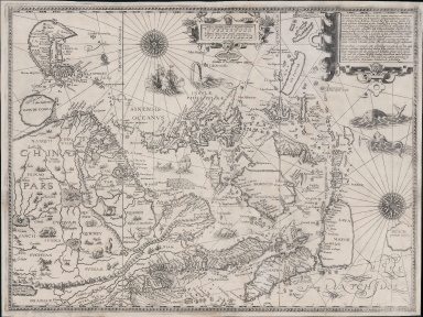
This map by Arnold Florent van Langren was engraved by Hendrik Floris van Langren for the 'Itinerario, voyage ofte schipvaert, van Jan Huygen van Linschoten naer Oost ofte Portugaels Indien' by Jan Huygen Linschoten. The work is basically an instruction sailing manual to the East Indies that help terminate Portuguese trade hegemony in Asia. It was among the most important sources of information on Southeast Asia during the 16th century. Linschoten acquired most of the information about Southeast Asia during his employment as secretary to the Portuguese archbishop in Goa from 1583 to 1589. This map is clearly based on Portuguese portolan charts, mostly from Fernão Vaz Dourado, Bartolomeu Lasso and Jorge Luís de Barbuda, however, there is also an influence from Plancius, that curiously enough also had Portuguese sources on the base of his maps. On the map are depicted China, Japan, Korea, the Philippines, Strait of Malacca, Borneo, Java, Timor and part of Papua New Guinea, there is also the mythical land of Marco Polo 'Beach provincia aurifera' where Australia would eventually be discovered. Korea is still depicted as an island as was common at the time. Japan is still represented in the 'Dourado type', opposed to the later 'Teixeira type', and China is obviously based on the map 'Chinae, olim Sinarum regionis, nova descriptio' by Barbuda, who depicts the interior with a network of rivers emanating from several large lakes.
|
|
Note:
|
Original is a copperplate printed map for the 'Itinerario, voyage ofte schipvaert, van Jan Huygen van Linschoten naer Oost ofte Portugaels Indien' by Jan Huygen Linschoten, 37 x 51 cm, on sheet 41 x 53 cm.
|
|
Note:
|
Inside the strap work cartouche of the scale line, on the bottom: "Henricus F. ab Langren sculpsit a.o 1595". Underneath the same cartouche: "Arnoldus F. à Langren delineavit."
|
|
Note:
|
Title on ornamented cartouche on the right upper corner of the map.
|
|
Note:
|
There are three vessels on the map and five sea monsters. In China are representations of many animals: elephant, camel, giraffe and rhinoceros. There are two 32-point compass roses on the map with a fleur-de-lis indicating north and a dot on the East point.
|
|
Note:
|
Map oriented with East at the top with latitude lines on both the top and bottom.
|
|
Note:
|
Scale lines in 'Miliaria Germanica' and 'Hispanicae leucae' inside strap work cartouche in the middle upper part of the map.
|
|
Note:
|
Relief shown pictorially.
|
|
Note:
|
Macao in Asia maps.
|
|
Note:
|
Parallel title in Latin and Dutch. Legends, Tropic of Cancer and the Equator, water masses and some land masses in Latin with place names in Portuguese and Spanish.
|
|
Reference:
|
Cortesão, A. Portugaliae Monumenta Cartographica, vol. III, p. 97-100
|
|
Reference:
|
Suarez, T. Early Mapping of Southeast Asia, p. 178-179
|
|
Reference:
|
Schilder, G. Australia Unveiled, Map 18
|
|
Reference:
|
Walter, L. Japan Cat., no. 12
|
|
Reference:
|
Quirino, C. Philippine cartography, p. 27, 77
|
|
Subject:
|
Early works to 1800
|
|
Geographic Area:
|
East Asia
|
|
Geographic Area:
|
China
|
|
Geographic Area:
|
Japan
|
|
Geographic Area:
|
Korea
|
|
Geographic Area:
|
Vietnam
|
|
Geographic Area:
|
Paracel Islands
|
|
Geographic Area:
|
Hainan Sheng (China)
|
|
Geographic Area:
|
Sumatra (Indonesia)
|
|
Geographic Area:
|
Java (Indonesia)
|
|
Geographic Area:
|
Borneo
|
|
Geographic Area:
|
Philippines
|
|
Geographic Area:
|
Papua New Guinea
|
|
Geographic Area:
|
Cambodia
|
|
Geographic Area:
|
Malaysia
|
|
Geographic Area:
|
Taiwan
|
|
Pub Title:
|
Itinerario, voyage ofte schipvaert, van Jan Huygen van Linschoten naer Oost ofte Portugaels Indien
|
|
Pub Author:
|
Linschoten, Jan Huygen van, 1563-1611
|
|
Pub Year:
|
1596
|
|
Pub location:
|
Amsterdam
|
|
Provenance:
|
Biblioteca Pública de Évora
|
|
Provenance:
|
http://evoraopacgib.bibliopolis.info/OPAC/b.aspx?CLI=EVORA&X1=Evora_GiB_Catalogo&id=76889
|
|
Provenance Call No.:
|
BPE-RES Gav 2 Pasta C nº 54
|
|
MUST holding:
|
https://must.primo.exlibrisgroup.com/permalink/853MUST_INST/171sgkf/alma991002923847905076
|