Detail View: Old Maps Collection: Carte des Isles Philippines Celebes et Moluques
|
Barcode:
|
3687800354414A
|
|
Title:
|
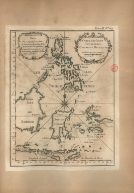
Carte des Isles Philippines Celebes et Moluques
|
|
Contributor:
|
Bellin, Jacques-Nicolas, 1703-1772, cartographer
|
|
Category:
|
General Maps
|
|
Type:
|
Printed
|
|
Language:
|
French
|
|
Create Year:
|
[1764]
|
|
Page No.:
|
64
|
|
Scale:
|
Scale indeterminable.
|
|
Physical Map Dimension (cm):
|
22 x 17 cm, on sheet 27 x 20 cm
|
|
Note:
|
This is a map of the Philippines, Borneo and part of Indonesia. It is not very detailed and is more of the outline of the very important Spice Islands. For trade purposes both the Philippines and the Maluku Islands, both of Spanish occupation, were one of the most important stations in Southeast Asia. The map doesn't present a great number of place names that according to the legend on the scroll work cartouche on the left upper corner of the map, was kept out purposely by the author as to facilitate the reading fo the map and not bring confusion in the quite overwhelming number of islands.
|
|
Note:
|
Original is a copperplate printed map in the 'Le petit atlas maritime: recueil de cartes et plans des quatre parties du monde'.
|
|
Note:
|
There is a 16-point compass rose on the map with a fleur-de-lis indicating north. Rhumb lines for the principal winds are bold and half-winds are dotted.
|
|
Note:
|
Title inside phytomorphic cartouche.
|
|
Note:
|
Scale line underneath the title in black and white interchangeably.
|
|
Note:
|
Relief shown pictorially.
|
|
Note:
|
Two borders of the map, left and bottom, with latitude and longitude lines in black and white interchangeably.
|
|
Note:
|
Equator line in double fillet. Prime meridian: Paris.
|
|
Note:
|
Landmasses outlined in green.
|
|
Note:
|
Map outlined in double fillet.
|
|
Reference:
|
Phillips, P.L. A list of geographical atlases in the Library of Congress, vol. 3, n.º 3508, p. 348-355
|
|
Subject:
|
Atlas
|
|
Geographic Area:
|
Asia
|
|
Geographic Area:
|
Java (Indonesia)
|
|
Geographic Area:
|
Timor Island
|
|
Geographic Area:
|
Indonesia
|
|
Geographic Area:
|
Borneo
|
|
Geographic Area:
|
Philippines
|
|
Geographic Area:
|
Papua New Guinea
|
|
Relation Note:
|
Tome III, n.º 64
|
|
Pub Title:
|
Petit atlas maritime : recueil de cartes et plans des quatre parties du monde
|
|
Pub Author:
|
Bellin, Jacques-Nicolas, 1703-1772
|
|
Pub Year:
|
1764
|
|
Pub location:
|
[Paris]
|
|
Provenance:
|
Biblioteca Nacional de Portugal
|
|
Provenance:
|
http://id.bnportugal.gov.pt/bib/catbnp/604917
|
|
Provenance Call No.:
|
C.A. 62 V.
|
|
MUST holding:
|
https://must.primo.exlibrisgroup.com/permalink/853MUST_INST/171sgkf/alma991002995149805076
|