Detail View: Old Maps Collection: Isle de Cheu-Chan ou Isle Chusan avec les costes et isles voisines
|
Barcode:
|
36878003544229
|
|
Title:
|
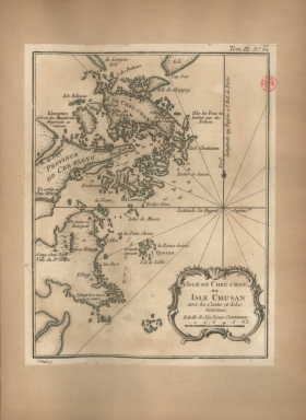
Isle de Cheu-Chan ou Isle Chusan avec les costes et isles voisines
|
|
Contributor:
|
Bellin, Jacques-Nicolas, 1703-1772, cartographer
|
|
Category:
|
General Maps
|
|
Type:
|
Manuscripts
|
|
Language:
|
French
|
|
Create Year:
|
[1764]
|
|
Scale:
|
Scale indeterminable.
|
|
Physical Map Dimension (cm):
|
22 x 17 cm, on sheet 26 x 21 cm
|
|
Note:
|
This map depicts the coast and islands of Zhejiang Province in China. It specially focus on the Zhoushan Island (Cheu-Chan) and the neighbouring coast. Zhoushan Island translates to Boat Island on account of its shape. It is the largest island in the Province of Zhejiang. On the map are marked several villages on the island and the inshore. It also provides some soundings for the sake of navigation on these parts.
|
|
Note:
|
Original is a copperplate printed map in the 'Le petit atlas maritime: recueil de cartes et plans des quatre parties du monde'.
|
|
Note:
|
There is a 16-point compass rose on the map with a fleur-de-lis indicating north. Rhumb lines for the principal winds are bold and half-winds are dotted.
|
|
Note:
|
Title inside scroll work cartouche.
|
|
Note:
|
Scale line underneath the title in black and white interchangeably.
|
|
Note:
|
Relief shown pictorially and bathymetric relief by soundings.
|
|
Note:
|
Landmasses outlined in green.
|
|
Note:
|
Map outlined in double fillet.
|
|
Reference:
|
Phillips, P.L. A list of geographical atlases in the Library of Congress, vol. 3, n.º 3508, p. 348-355
|
|
Geographic Area:
|
Zhoushan Archipelago (China)
|
|
Relation Note:
|
Tome III, n.º 61
|
|
Pub Title:
|
Petit atlas maritime : recueil de cartes et plans des quatre parties du monde
|
|
Pub Author:
|
Bellin, Jacques-Nicolas, 1703-1772
|
|
Pub Year:
|
1764
|
|
Pub location:
|
[Paris]
|
|
Provenance:
|
Biblioteca Nacional de Portugal
|
|
Provenance:
|
http://id.bnportugal.gov.pt/bib/catbnp/604917
|
|
Provenance Call No.:
|
C.A. 62 V.
|
|
MUST holding:
|
https://must.primo.exlibrisgroup.com/permalink/853MUST_INST/171sgkf/alma991002995849805076
|