Detail View: Old Maps Collection: [Carta da China].
|
Barcode:
|
3687800354427E
|
|
Title:
|
[Carta da China].
|
|
Category:
|
General Maps
|
|
Type:
|
Printed
|
|
Language:
|
Portuguese
|
|
Create Year:
|
[ca. 1770]
|
|
Physical Map Dimension (cm):
|
Scale not given.
|
|
Note:
|
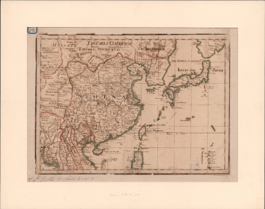
This map is a manuscript made to mimic a copperplate printed map very common on the 18th century. It depicts China with the islands of Taiwan (Ilha Formoza) and Hainan (Islha de Aynaõ), Japan, Korea, the northern part of the Philippine Island of Luzon and part of Tartary. Japan (Ilhas do Japam) is already depicted in the Teixeira-type and with the Island of Hokkaido b+named as 'Yesso' as common at the time. Korea (R.º de Corea) is correctly depicted as a peninsula even though with a very distorted shape and still with very few place names, specially if compared with the interior of China.
|
|
Note:
|
Original is a manuscript map, 32 x 45 cm, on sheet 38 x 51 cm.
|
|
Note:
|
According to the reference work there was once a "Miranda fecit, Lx.ª" in one of the corners of the map.
|
|
Note:
|
Tropic of Cancer in double line.
|
|
Note:
|
Relief shown pictorially.
|
|
Note:
|
Landmasses outlined in green and magenta, with small islands colored green.
|
|
Note:
|
Map with graticule.
|
|
Note:
|
The four borders of the map with latitude and longitude lines in black and white interchangeably.
|
|
Note:
|
Map outlined in bold fillet.
|
|
Note:
|
Macao in China maps.
|
|
Reference:
|
Rivara, C.J. Catálogo dos manuscritos da Biblioteca Pública Eborense, vol. 1, p. 11
|
|
Subject:
|
Early works to 1800
|
|
Geographic Area:
|
East Asia
|
|
Geographic Area:
|
China
|
|
Geographic Area:
|
Japan
|
|
Geographic Area:
|
Korea
|
|
Geographic Area:
|
Paracel Islands
|
|
Geographic Area:
|
Hainan Sheng (China)
|
|
Geographic Area:
|
Philippines
|
|
Geographic Area:
|
Taiwan
|
|
Provenance:
|
Biblioteca Pública de Évora
|
|
Provenance:
|
http://evoraopacgib.bibliopolis.info/OPAC/b.aspx?CLI=EVORA&X1=Evora_GiB_Catalogo&id=76888
|
|
Provenance Call No.:
|
BPE-RES Gav 4 Pasta A nº 9.
|
|
MUST holding:
|
https://must.primo.exlibrisgroup.com/permalink/853MUST_INST/171sgkf/alma991002995849505076
|