Detail View: Old Maps Collection: A plan of the city and harbour of Macao : a colony of the Portugueze, situated at the southern extremity of the Chinese Empire in Lat. 22 ⁰12ʹ44ʺ N., long. 113°35ʹ0ʺ east of Greenwich
|
Barcode:
|
4687820500220
|
|
Title:
|
A plan of the city and harbour of Macao : a colony of the Portugueze, situated at the southern extremity of the Chinese Empire in Lat. 22 ⁰12ʹ44ʺ N., long. 113°35ʹ0ʺ east of Greenwich
|
|
Original Title:
|
A plan of the city and harbour of Macao : a colony of the Portugueze, situated at the southern extremity of the Chinese Empire in Lat. 22 ⁰12ʹ44ʺ N., long. 113°35ʹ0ʺ east of Greenwich
|
|
Contributor:
|
Baker, B. (Benjamin), active 1766-1824
|
|
Category:
|
City Plans & Views
|
|
Type:
|
Printed
|
|
Language:
|
English
|
|
Create Year:
|
1796
|
|
Format:
|
JPEG, 6750 × 9227, 63.3MB
|
|
Scale:
|
[ca. 1:32,600] (E 113⁰35ʹ00ʺ/N 22⁰12ʹ44ʺ)
|
|
Physical Map Dimension (cm):
|
69 × 52
|
|
Note:
|
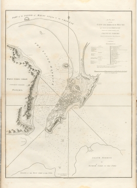
The map described the macao city in detail in macao city of the hydrological and topography . Terrain is shown as engraved hills and the waters are filled with soundings and notations on type of bottom. It is shown city with a important to thirty-six buildings and places, including forts, parishes, colleges, convents and chapels. The fortified city of Tchin-shang(Qianshan) is shown well north of Macao.
|
|
Note:
|
City Plans of Macao
|
|
Note:
|
Macao and its Surroundings
|
|
Geographic Area:
|
Macao (China)
|
|
Relation Note:
|
Baker map of the city and harbour of Macao
|
|
Pub Title:
|
An authentic account of an embassy from the King of Great Britain to the Emperor of China; including cursory observations made, and information obtained in travelling through that ancient empire, and a small part of Chinese Tartary
|
|
Pub Author:
|
Staunton, George, Sir, 1737-1801
|
|
Pub Year:
|
1797
|
|
Pub location:
|
London
|
|
Provenance:
|
Harvard Map Collection - Harvard College Library
|