Detail View: Old Maps Collection: Table of jours, vents, routes, lieuës, latitudes, longitudes, variantions and courans, May 1698].
|
Barcode:
|
3687800354385H
|
|
Title:
|
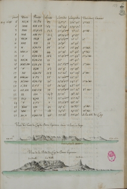
Table of jours, vents, routes, lieuës, latitudes, longitudes, variantions and courans, May 1698].
|
|
Other Title:
|
Veuë des terres du Cap de Bonne Esperance étant 3. lieuës au large.
|
|
Other Title:
|
Veue de la Rade du Cap de Bonne Esperance.
|
|
Contributor:
|
Froger, François, 1676-1715, author
|
|
Category:
|
Itinerary
|
|
Type:
|
Manuscripts
|
|
Language:
|
French
|
|
Create Year:
|
[ca. 1698]
|
|
Page No.:
|
177
|
|
Scale:
|
Scale not given.
|
|
Physical Map Dimension (cm):
|
31 x 21 cm, on sheet 37 x 27 cm
|
|
Note:
|
This is an itinerary of the voyage to China in the years 1698 to 1700 on board of L'Amphirite. The itinerary is mostly in tables with the information of the winds, the route, the leagues, latitude and longitude, variations and currents given by day. However, one can also find detailed coastal profiles of some of the most important locations of the voyage and a plan of Pol Vereyra.
|
|
Note:
|
Original is a colored manuscript map from the manuscript 'Relation du Premier voyage des François a la Chine' by François Froger.
|
|
Note:
|
Relief shown pictorially and by landforms.
|
|
Subject:
|
Itinerary
|
|
Geographic Area:
|
Cape of Good Hope
|
|
Relation Note:
|
[fol. 177 r.]
|
|
Pub Title:
|
Relation du Premier voyage des François a la Chine
|
|
Pub Author:
|
Froger, François, 1676-1715
|
|
Pub Year:
|
1698-1700
|
|
Pub location:
|
[S.l.]
|
|
Provenance:
|
Biblioteca da Ajuda
|
|
Provenance Call No.:
|
52-XIV-23
|
|
MUST holding:
|
https://must.primo.exlibrisgroup.com/permalink/853MUST_INST/171sgkf/alma991002992949305076
|