Detail View: Old Maps Collection: Pol Mintoon en étant 4, lieuës au large.
|
Barcode:
|
3687800354388K
|
|
Title:
|
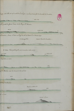
Pol Mintoon en étant 4, lieuës au large.
|
|
Other Title:
|
Pol Mintoon de 2. lieuës au large.
|
|
Other Title:
|
Veuë des isles du nord de la Rade d'Achem, et des hautes terres de Sumatra, étant 5 lieuës au large du coté du Ouëst.
|
|
Other Title:
|
Montagne pour Porselar and deux islots.
|
|
Other Title:
|
Terreferme de Malaca.
|
|
Other Title:
|
Pol Aros de 3 lieuës au large.
|
|
Other Title:
|
Terre ferme de Malaca and Montagne de Porselar.
|
|
Other Title:
|
Autre veuë de Porselar lors qu'il reste au NE 1/4 E. 4. lieuës
|
|
Contributor:
|
Froger, François, 1676-1715, author
|
|
Category:
|
Itinerary
|
|
Type:
|
Manuscripts
|
|
Language:
|
French
|
|
Create Year:
|
[ca. 1698]
|
|
Page No.:
|
180
|
|
Scale:
|
Scale not given.
|
|
Physical Map Dimension (cm):
|
32 x 22 cm, on sheet 38 x 28 cm or smaller
|
|
Note:
|
This is an itinerary of the voyage to China in the years 1698 to 1700 on board of L'Amphirite. The itinerary is mostly in tables with the information of the winds, the route, the leagues, latitude and longitude, variations and currents given by day. However, one can also find detailed coastal profiles of some of the most important locations of the voyage and a plan of Pol Vereyra.
|
|
Note:
|
Original is a colored manuscript map from the manuscript 'Relation du Premier voyage des François a la Chine' by François Froger.
|
|
Note:
|
Relief shown pictorially and by landforms.
|
|
Subject:
|
Itinerary
|
|
Geographic Area:
|
Malacca (Malacca, Malaysia)
|
|
Relation Note:
|
[fol. 180 r.]
|
|
Pub Title:
|
Relation du Premier voyage des François a la Chine
|
|
Pub Author:
|
Froger, François, 1676-1715
|
|
Pub Year:
|
1698-1700
|
|
Pub location:
|
[S.l.]
|
|
Provenance:
|
Biblioteca da Ajuda
|
|
Provenance Call No.:
|
52-XIV-23
|
|
MUST holding:
|
https://must.primo.exlibrisgroup.com/permalink/853MUST_INST/171sgkf/alma991002992949305076
|