Detail View: Old Maps Collection: Carte de l'Isle Formose aux costes de la Chine
|
Barcode:
|
3687800354419F
|
|
Title:
|
Carte de l'Isle Formose aux costes de la Chine
|
|
Contributor:
|
Bellin, Jacques-Nicolas, 1703-1772, cartographer
|
|
Category:
|
General Maps
|
|
Type:
|
Printed
|
|
Language:
|
French
|
|
Create Year:
|
[1764]
|
|
Page No.:
|
59
|
|
Scale:
|
Scale indeterminable.
|
|
Physical Map Dimension (cm):
|
22 x 17 cm, on sheet 27 x 21 cm
|
|
Note:
|
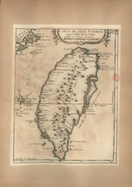
This is a map of the island of Taiwan(Tai-Ouan ou Isle Formose) with the Penghu or Pescadores archipelago and part of the coast of China on the left upper corner. The interior is mostly blank with the relief and so most of the place names are in the inshore areas.
|
|
Note:
|
Original is a copperplate printed map in the 'Le petit atlas maritime: recueil de cartes et plans des quatre parties du monde'.
|
|
Note:
|
Title inside scroll work phytomorphic cartouche.
|
|
Note:
|
Scale line underneath the title in black and white interchangeably.
|
|
Note:
|
Relief shown pictorially.
|
|
Note:
|
Latitude and longitude lines on the bottom and right borders of the map.
|
|
Note:
|
Landmasses outlined in green.
|
|
Note:
|
Tropic of Cancer in double fillet.
|
|
Note:
|
Map outlined in simple fillet.
|
|
Reference:
|
Phillips, P.L. A list of geographical atlases in the Library of Congress, vol. 3, n.º 3508, p. 348-355
|
|
Subject:
|
Atlas
|
|
Geographic Area:
|
China
|
|
Geographic Area:
|
Taiwan
|
|
Relation Note:
|
Tome III, n.º 59
|
|
Pub Title:
|
Petit atlas maritime : recueil de cartes et plans des quatre parties du monde
|
|
Pub Author:
|
Bellin, Jacques-Nicolas, 1703-1772
|
|
Pub Year:
|
1764
|
|
Pub location:
|
[Paris]
|
|
Provenance:
|
Biblioteca Nacional de Portugal
|
|
Provenance:
|
http://id.bnportugal.gov.pt/bib/catbnp/604917
|
|
Provenance Call No.:
|
C.A. 62 V.
|
|
MUST holding:
|
https://must.primo.exlibrisgroup.com/permalink/853MUST_INST/171sgkf/alma991002995549805076
|