Detail View: Old Maps Collection: Carte de l'Empire du Japon
|
Barcode:
|
3687800354418E
|
|
Title:
|
Carte de l'Empire du Japon
|
|
Contributor:
|
Bellin, Jacques-Nicolas, 1703-1772, cartographer
|
|
Category:
|
General Maps
|
|
Type:
|
Printed
|
|
Language:
|
French
|
|
Create Year:
|
[1764]
|
|
Page No.:
|
62
|
|
Scale:
|
Scale indeterminable.
|
|
Physical Map Dimension (cm):
|
21 x 31 cm, on sheet 25 x 33 cm
|
|
Note:
|
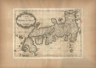
This map depicts the island of Japan showing provinces (delineated via dotted lines), islands, towns, mountains and rivers. It was one of the best maps of Japan from the mid-18th century. The main island of Honshu is named as 'Isle de Nipon', Kyushu is marked 'Isle de Ximo' and Shikoku as 'I. de Xixoco'. The map is however missing the island of Hokkaido that was already standard at the time with the name of Yezo.
|
|
Note:
|
Original is a copperplate printed map in the 'Le petit atlas maritime: recueil de cartes et plans des quatre parties du monde'.
|
|
Note:
|
Title inside scroll work phytomorphic cartouche.
|
|
Note:
|
Scale line underneath the title in black and white interchangeably.
|
|
Note:
|
Relief shown pictorially.
|
|
Note:
|
The four borders of the map with latitude and longitude lines in black and white interchangeably.
|
|
Note:
|
Landmasses outlined in green.
|
|
Note:
|
Map with graticule.
|
|
Note:
|
Map outlined in simple fillet.
|
|
Reference:
|
Phillips, P.L. A list of geographical atlases in the Library of Congress, vol. 3, n.º 3508, p. 348-355
|
|
Subject:
|
Early works to 1800
|
|
Geographic Area:
|
Japan
|
|
Relation Note:
|
Tome III, n.º 62
|
|
Pub Title:
|
Petit atlas maritime : recueil de cartes et plans des quatre parties du monde
|
|
Pub Author:
|
Bellin, Jacques-Nicolas, 1703-1772
|
|
Pub Year:
|
1764
|
|
Pub location:
|
[Paris]
|
|
Provenance:
|
Biblioteca Nacional de Portugal
|
|
Provenance:
|
http://id.bnportugal.gov.pt/bib/catbnp/604917
|
|
Provenance Call No.:
|
C.A. 62 V.
|
|
MUST holding:
|
https://must.primo.exlibrisgroup.com/permalink/853MUST_INST/171sgkf/alma991002995549705076
|