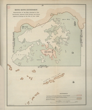
Detail View: Old Maps Collection: Hong Kong extension : reproduction of the map attached to the Convention between Great Britain and China signed at Peking on the 9th of June 1898.
|
Barcode:
|
3687800354432A
|
|
Title:
|
Hong Kong extension : reproduction of the map attached to the Convention between Great Britain and China signed at Peking on the 9th of June 1898.
|
|
Contributor:
|
L.L. Poates Engr'g Co., printer
|
|
Category:
|
General Maps
|
|
Type:
|
Printed
|
|
Language:
|
English
|
|
Language:
|
Chinese
|
|
Create Year:
|
[1921]
|
|
Page No.:
|
5
|
|
Scale:
|
Scale indeterminable.
|
|
Physical Map Dimension (cm):
|
31 x 24 cm, on sheet 39 x 30 cm
|
|
Note:
|
The map is a reproduction of the one attached to the Convention between the United Kingdom and China, Respecting an Extension of Hong Kong Territory, commonly known as the Convention for the Extension of Hong Kong Territory or the Second Convention of Peking. This Convention was a lease signed between Qing China and the United Kingdom on 9 June 1898. After China's defeat in the First Sino-Japanese War (1894–1895), the British took advantage of other European powers' to force the treaty on the weakened Chinese government. Between 6 March and 8 April 1898, the German government forced the Qing Empire into a 99-year lease of the Kiautschou Bay concession for a coaling station around Jiaozhou Bay on the southern coast of the Shandong Peninsula, to support a German global naval presence in direct opposition to the British network of global naval bases. This initiated a series of similar lease treaties with other European powers. In order to maintain the balance of powers, Britain pressures the Qing Empire into allowing the expansion of Hong Kong for 200 miles. The contract was signed to give the British full jurisdiction of the newly acquired land. Under the convention the territories north of Boundary Street and south of Sham Chun River, and the surrounding islands were leased to the United Kingdom for 99 years rent-free, expiring on 30 June 1997 becoming part of the colony of Hong Kong.
|
|
Note:
|
Original is a printed map.
|
|
Note:
|
On the left bottom corner of the map: "L.L. Poates Co. N.Y."
|
|
Note:
|
Scale line in miles on the bottom right corner of the map.
|
|
Note:
|
Map outlined in double fillet.
|
|
Note:
|
Title and legend in English with some place names and latitude and longitude degrees in Chinese.
|
|
Subject:
|
China
|
|
Geographic Area:
|
Lamma Island (Hong Kong)
|
|
Relation Note:
|
Vol. 1, [pl. 5]
|
|
Pub Title:
|
Treaties and agreements with and concerning China : 1894-1919
|
|
Pub Author:
|
MacMurray, John Van Antwerp, 1881-1960.
|
|
Pub Year:
|
1921
|
|
Pub location:
|
New York
|
|
Provenance:
|
Biblioteca Nacional de Portugal
|
|
Provenance:
|
http://id.bnportugal.gov.pt/bib/catbnp/430625
|
|
Provenance Call No.:
|
H.G. 19138 V.
|
|
MUST holding:
|
https://must.primo.exlibrisgroup.com/permalink/853MUST_INST/171sgkf/alma991002997249705076
|