Detail View: Old Maps Collection: Railway map of China : Peking, Oct. 1918
|
Barcode:
|
36878003544319
|
|
Title:
|
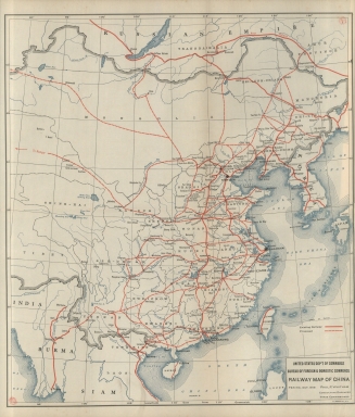
Railway map of China : Peking, Oct. 1918
|
|
Contributor:
|
United States. Bureau of Foreign and Domestic Commerce, author
|
|
Contributor:
|
Whitham, Paul Page, 1878-1941, author
|
|
Contributor:
|
L.L. Poates Engr'g Co., printer
|
|
Category:
|
General Maps
|
|
Type:
|
Printed
|
|
Language:
|
English
|
|
Create Year:
|
[1921]
|
|
Page No.:
|
1
|
|
Scale:
|
Scale not given.
|
|
Physical Map Dimension (cm):
|
43 x 38 cm, on sheet 48 x 41 cm
|
|
Note:
|
The map depicts the existing and proposed railway mainly in China but also in Laos, Myanmar, Mongolia, Russia and Korea.
|
|
Note:
|
Original is a printed map.
|
|
Note:
|
On the right bottom corner of the map: "L.L. Poates Co. N.Y."
|
|
Note:
|
Map with graticule.
|
|
Note:
|
Bathymetric relief shown by isolines.
|
|
Note:
|
The four borders of the map with latitude and longitude lines.
|
|
Note:
|
Tropic of Cancer in dashed line.
|
|
Note:
|
Map outlined in double fillet.
|
|
Note:
|
Macao in China maps.
|
|
Subject:
|
China
|
|
Geographic Area:
|
China
|
|
Geographic Area:
|
Korea
|
|
Geographic Area:
|
Hainan Sheng (China)
|
|
Geographic Area:
|
Taiwan
|
|
Geographic Area:
|
Laos
|
|
Geographic Area:
|
Myanmar
|
|
Geographic Area:
|
Mongolia
|
|
Geographic Area:
|
Russia
|
|
Provenance:
|
Biblioteca Nacional de Portugal
|
|
Provenance:
|
http://id.bnportugal.gov.pt/bib/catbnp/430625
|
|
Provenance Call No.:
|
H.G. 19138 V.
|
|
MUST holding:
|
https://must.primo.exlibrisgroup.com/permalink/853MUST_INST/171sgkf/alma991002996549705076
|